Latitude: 51.6391 / 51°38'20"N
Longitude: -3.8114 / 3°48'41"W
OS Eastings: 274743
OS Northings: 194925
OS Grid: SS747949
Mapcode National: GBR H2.7XPM
Mapcode Global: VH4KC.W2D8
Plus Code: 9C3RJ5QQ+MC
Entry Name: Bridge over Ynysmaerdy Incline
Listing Date: 19 May 2000
Last Amended: 19 May 2000
Grade: II
Source: Cadw
Source ID: 23308
Building Class: Transport
ID on this website: 300023308
Location: On the E side of Jersey Park immediately S of Ynysmaerdy Cemetery and W of the upper end of Ynysmaerdy Road.
County: Neath Port Talbot
Community: Briton Ferry (Llansawel)
Community: Briton Ferry
Locality: Jersey Park
Traditional County: Glamorgan
Tagged with: Bridge
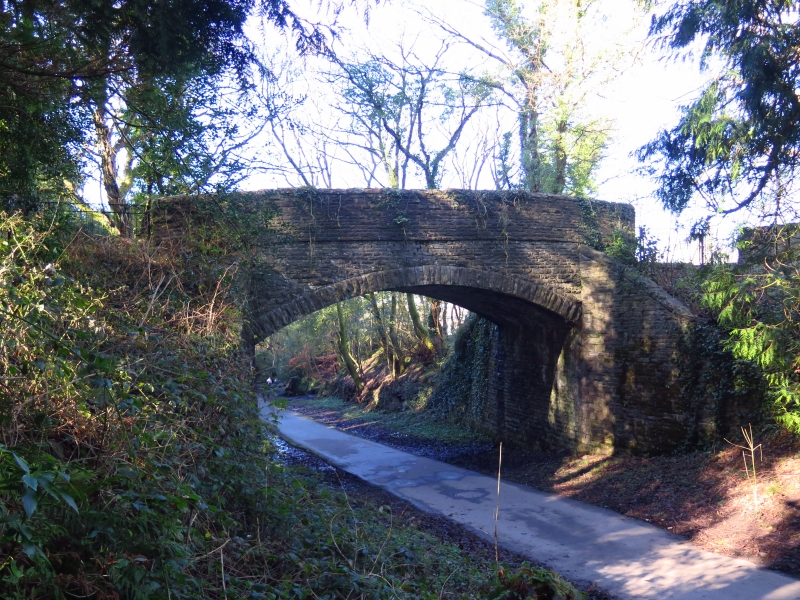
The South Wales Mineral Railway was incorporated in 1853 for a 13-mile cross-country line from the collieries at Glyncorrwg to the docks at Briton Ferry. The route was laid out by Isambard Kingdom Brunel, who was later succeeded by R.P. Brereton. At the Briton Ferry end a double-tracked cable-worked incline 1.5 miles long was required to overcome the steep terrain. The railway opened in 1861 from Briton Ferry to Tonmawr and to Glyncorrwg in 1863. Originally broad gauge, it was converted to standard gauge in 1872. The railway incline was an antiquated concept by the mid C19 and was expensive to operate. The railway was never a financial success, partly due to the vicissitudes of colliery companies in Glyncorrwg who operated the line. In 1908 the line was taken over by the Great Western Railway, who closed the incline in 1910. The lower part of the incline, including the integral bridge adjacent to the former Ynysmaerdy Farm, was subsequently incorporated into Jersey Park, designed by the Borough engineer H. Alexander Clarke and opened in 1925.
A single-span bridge of snecked rock-faced stone and with a wide segmental arch (required to span a double broad-gauge track). The high parapet projects slightly and has rock-faced copings. Abutments are splayed out slightly and have a raking top with rock-faced copings. The flat deck is a wide single track and is covered with soil. On both sides the approaches, slightly ramped, are from the E.
Listed as an original built component of the Ynysmaerdy Incline and designed by the office of one of Britain's most influential engineers.
Scheduled Ancient Monument Gm 489.
External links are from the relevant listing authority and, where applicable, Wikidata. Wikidata IDs may be related buildings as well as this specific building. If you want to add or update a link, you will need to do so by editing the Wikidata entry.


Other nearby listed buildings