Approximate Location Map
Large Map »
Latitude: 51.6524 / 51°39'8"N
Longitude: -3.6524 / 3°39'8"W
OS Eastings: 285778
OS Northings: 196134
OS Grid: SS857961
Mapcode National: GBR H9.720M
Mapcode Global: VH5GQ.MQYN
Plus Code: 9C3RM82X+W2
Entry Name: Cymmer Viaduct
Listing Date: 31 July 2000
Last Amended: 31 July 2000
Grade: II
Source: Cadw
Source ID: 23843
Building Class: Communications
ID on this website: 300023843
Location: Spanning the Afan river approximately 0.5km WNW of the centre of Cymmer.
County: Neath Port Talbot
Community: Glyncorrwg
Community: Glyncorrwg
Locality: Cymmer
Built-Up Area: Cymmer
Traditional County: Glamorgan
Tagged with: Viaduct Railway viaduct
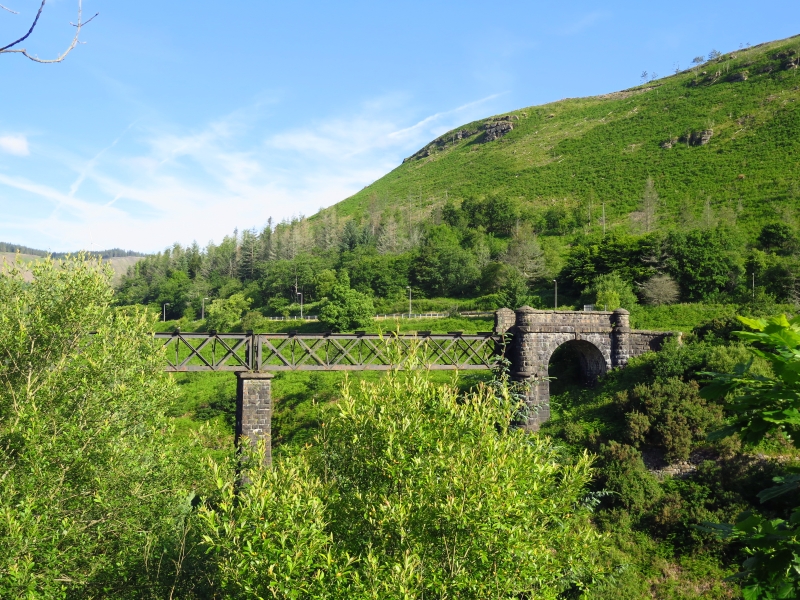
Opened in 1878 and built by the Great Western Railway to link the South Wales Mineral Railway (which ran from the Glyncorrwg collieries to Briton Ferry) with the same company's Bridgend-Abergwynfi line. The piers are of locally quarried stone and are shown in the process of erection on the first edition Ordnance Survey. The line closed in 1970.
A wrought-iron lattice-girder viaduct aligned roughly N-S and with a slightly curved deck. The main abutments are of coursed rock-faced stone, and comprise a round arch with keystone, above which is a string course and coped parapet. The arches are flanked by round turrets that are carried up the full height of the parapets. On the N side the parapets curve outwards and terminate in square piers. On the S side is a further abutment that carried a second girder bridge over the adjacent former Rhondda and Swansea Bay Railway (now the Afan Valley Cycle Way).
The lattice girders are carried on 3 tapering rectangular piers of rock-face stone and moulded copings. The girders are constructed in 4 straight sections and retain some timber cross members on the deck.
Listed as a good early example of a lattice-girder viaduct, of a type later commonly employed to span the South Wales valleys.
External links are from the relevant listing authority and, where applicable, Wikidata. Wikidata IDs may be related buildings as well as this specific building. If you want to add or update a link, you will need to do so by editing the Wikidata entry.


Other nearby listed buildings
