Approximate Location Map
Large Map »
Latitude: 51.5618 / 51°33'42"N
Longitude: -3.3706 / 3°22'14"W
OS Eastings: 305084
OS Northings: 185664
OS Grid: ST050856
Mapcode National: GBR HP.DT09
Mapcode Global: VH6DX.J0FJ
Plus Code: 9C3RHJ6H+PP
Entry Name: Gates, piers, boundary walls and bridge at Castellau Congregational Chapel
Listing Date: 18 August 2000
Last Amended: 18 August 2000
Grade: II
Source: Cadw
Source ID: 23949
Building Class: Religious, Ritual and Funerary
ID on this website: 300023949
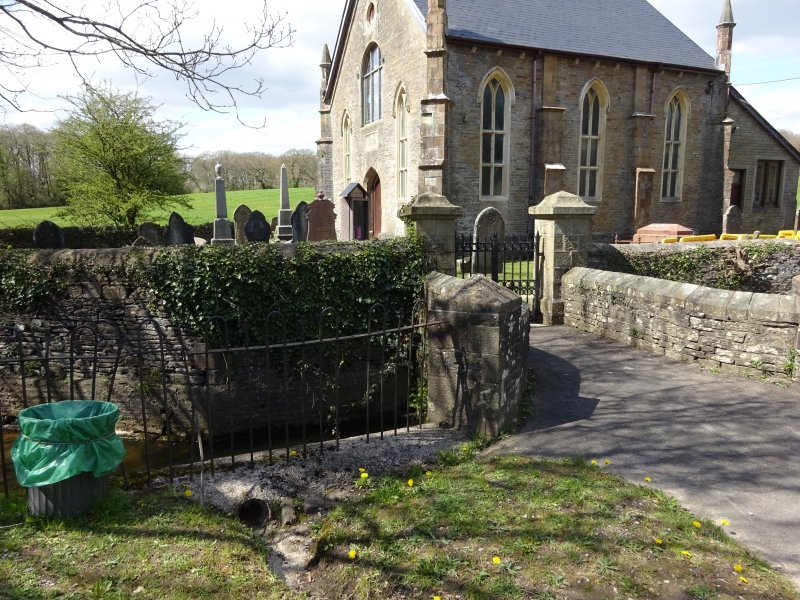
Location: Forming the entrance to the semi-circular graveyard and chapel off the W side of the lane.
County: Rhondda Cynon Taff
Town: Pontyclun
Community: Llantrisant
Community: Llantrisant
Traditional County: Glamorgan
Tagged with: Bridge
A chapel was originally built on the site in 1843 and was rebuilt in 1877. The brook which the bridge spans was formerly used for Baptisms.
The Nant Castellau curves around the E side of the graveyard and forms its boundary. The entrance to the graveyard and chapel consists of a bridge over the stream, leading to cast iron gates flanked by piers, beyond which is rubble stone walling with rendered copings. Small bridge of snecked stone with single pointed arch of narrow voussoirs and flat deck. Continuous parapets and dressed stone saddleback copings. Splayed ends to E, terminating in square piers set at an angle with pyramidal capstones. Taller dressed stone piers to W surmounted by ornate pyramidal capstones with hollow mouldings. These flank double cast iron gates with pointed finials and double top, mid and dog rails bearing bands of circles.
Listed for group value with Castellau Chapel, and contributing to its picturesque setting.
External links are from the relevant listing authority and, where applicable, Wikidata. Wikidata IDs may be related buildings as well as this specific building. If you want to add or update a link, you will need to do so by editing the Wikidata entry.


Other nearby listed buildings
