Latitude: 51.912 / 51°54'43"N
Longitude: -2.8685 / 2°52'6"W
OS Eastings: 340354
OS Northings: 224072
OS Grid: SO403240
Mapcode National: GBR FC.PR2Z
Mapcode Global: VH78X.76DM
Plus Code: 9C3VW46J+QH
Entry Name: Stable at Great Tresenny
Listing Date: 19 October 2000
Last Amended: 19 October 2000
Grade: II
Source: Cadw
Source ID: 24146
Building Class: Agriculture and Subsistence
ID on this website: 300024146
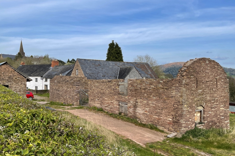
Location: The stable block is attached to the S gable of Great Tresenny farmhouse. The farm lies about 300m S of Grosmont village on the E side of the minor road leading S from Grosmont to Hoaldalbert.
County: Monmouthshire
Town: Abergavenny
Community: Grosmont (Y Grysmwnt)
Community: Grosmont
Locality: Tresenny
Traditional County: Monmouthshire
Tagged with: Stable
An early C18 stable block, probably built for Thomas Parry of Great Tresenny c1722 at the same time as the adjoining barn.
Two storey range. Rubble stone with slate roof. Symmetrical W front faces farmyard. Pair of centre doorways and square-shaped windows to left and right. Openings have segmental arched heads and stone voussoirs. Doors are boarded and in two halves (door to right has attached C20 corrugated metal sheet). Windows are 2-light mullions (window to right lacks centre mullion). Loft of stable extends beyond gable into roof of adjoining barn. Below, on ground floor is a passageway between stable and barn which contains (in gable of stable) a square window with boarded shutter.
At the date of resurvey, the left stable had been converted into a cowhouse, but a wooden manger survived in the stable to right.
Included as a well-preserved C18 stable, having group value with the farmhouse and listed barn at Great Tresenny.
External links are from the relevant listing authority and, where applicable, Wikidata. Wikidata IDs may be related buildings as well as this specific building. If you want to add or update a link, you will need to do so by editing the Wikidata entry.


Other nearby listed buildings