Approximate Location Map
Large Map »
Latitude: 51.6023 / 51°36'8"N
Longitude: -3.3307 / 3°19'50"W
OS Eastings: 307933
OS Northings: 190109
OS Grid: ST079901
Mapcode National: GBR HQ.BBWV
Mapcode Global: VH6DK.7Z1L
Plus Code: 9C3RJM29+WP
Entry Name: Newbridge Chainworks Canal Basin on the Glamorganshire Canal
Listing Date: 26 February 2001
Last Amended: 26 February 2001
Grade: II
Source: Cadw
Source ID: 24855
Building Class: Transport
ID on this website: 300024855
Location: On the S side of Ynysangharad Road and to the rear of the Bunch of Grapes public house.
County: Rhondda Cynon Taff
Town: Pontypridd
Community: Pontypridd
Community: Pontypridd
Locality: Pentrebach
Built-Up Area: Pontypridd
Traditional County: Glamorgan
Tagged with: Canal basin
The Glamorganshire Canal Act was passed in 1790 and the canal opened in 1794 from Merthyr Tydfil to Cardiff, primarily to serve the growing output of the ironworks at Merthyr Tydfil. Its engineers were Thomas Dadford and Thomas Sheasby. The steep gradient between Merthyr and Cardiff - a fall of 165.5m in 40.2km - was overcome by erecting 51 locks, instead of the inclined planes favoured on other canals. These included a triple lock at Nantgarw (which has not survived) and the double lock at Pontypridd. The rapid growth in output of iron soon led to congestion on the canal, however, but the large volume of trade from the ironworks ensured that the canal survived the opening of the Taff Vale Railway in 1841. Traffic declined sharply when the ironworks declined in the late C19 and coal companies preferred rail transport. The upper section N of Pontypridd was almost disused by the late C19, but the section between Nantgarw and Pontypridd did not close until a breach at Nantgarw in 1942.
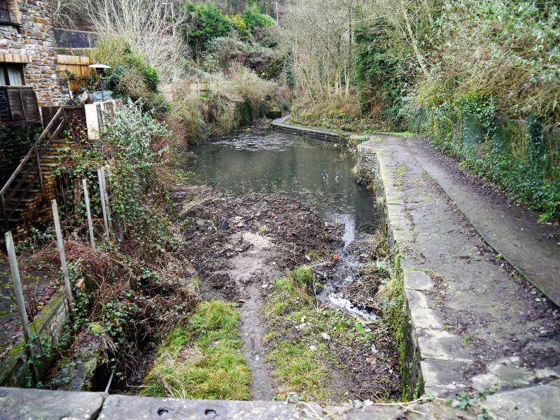
The canal basin was created probably in the mid C19 specifically to serve the nearby Newbridge Chainworks, as it is not shown on the 1841 Eglwysilan Tithe map.
A canal basin of snecked rubble walls and flat dressed copings, oriented roughly N-S. The basin opens out on both sides. On the W side the level of the towpath descends gradually from N-S. The S end has later concrete slab copings, while the towpath is laid with later concrete. An outflow culvert near the N end has a dressed stone surround, immediately S of which is a butt joint defining the widening of the original canal to create the basin. On the E side the wall is visible only on the northern half of the basin, as a later retaining wall is built over the remainder. The E wall is clearly of 2 phases as an earlier coping course is visible in the wall below the present coping level.
Listed for industrial archaeological interest as one of the relatively few surviving features on the Glamorganshire Canal and for group value with the adjacent canal bridge and Locks 31 & 32.
External links are from the relevant listing authority and, where applicable, Wikidata. Wikidata IDs may be related buildings as well as this specific building. If you want to add or update a link, you will need to do so by editing the Wikidata entry.


Other nearby listed buildings
