Approximate Location Map
Large Map »
Latitude: 53.3085 / 53°18'30"N
Longitude: -3.4179 / 3°25'4"W
OS Eastings: 305622
OS Northings: 379995
OS Grid: SJ056799
Mapcode National: GBR 4ZK5.VQ
Mapcode Global: WH76G.G3NH
Plus Code: 9C5R8H5J+9V
Entry Name: Clive Engine House, Talargoch Mine
Listing Date: 10 December 2001
Last Amended: 27 October 2010
Grade: II*
Source: Cadw
Source ID: 25956
Building Class: Industrial
Also known as: Clive Engine House, Meliden
Clive Engine House
ID on this website: 300025956
Location: About 50 m east of the A457 Dyserth to Prestatyn road, south of the Graig Park hotel and country club.
County: Denbighshire
Community: Dyserth
Community: Dyserth
Locality: Talargoch
Built-Up Area: Meliden
Traditional County: Flintshire
Tagged with: Building Engine house
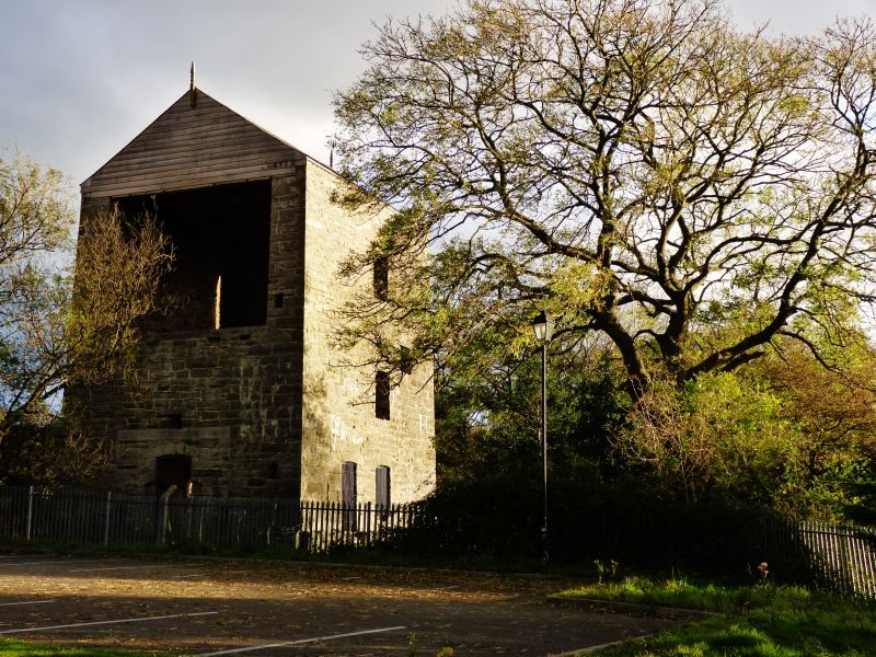
A Cornish Engine House built in 1862 for a £100 (30.5 m) pumping engine serving the Talargoch lead mine. A keystone over the main arch is marked ''1860''. In 1871 there was a shaft a short distance to the north-west, also secondary structures attached to the engine house on the west side and minor buildings to the south-east. The engine house became disused in 1883 and the mine closed in 1884.
Lead mining here can be traced back at least to 1699. It flourished in the late C18 when a Newcomen engine was employed for drainage. That was doubtless the ''Dalargoch Engine'' marked here on the Tithe Map (1839), when the property (Plymouth Estate) had come by marriage to the Rt Hon Robert Henry Clive. Another underground engine for mine pumping was installed in 1845. In the mid-C19 the trade was in decline but in a short lived revival in the 1860s the present building was erected for a Cornish Engine, and has always been named the Clive Engine House. In a prospectus seeking to re-start the mine in the early C20 it was stated the mine possessed plant capable of pumping 2000 gallons of water a minute.
A large Cornish Engine House, about 13m by 11m., in axe-dressed uncoursed limestone masonry with ashlar arches to openings. Slate roof with a decorative wood finial surviving at the north apex; similar at south apex recently lost. The roof is of four bays with king-post trusses. The north (front) wall above tie-beam level is weatherboarded.
The bob-wall is to the north, about 2m in thickness, and continues up to about 6m below the level of the roof. The opening through this at ground level is arched. There is another opening beneath it at basement level, facing the very large circular shaft lined in brick and stone.
Four windows in the west wall with low segmental arches. East side ivy-covered but with a small opening at high level. The south side has a large central arched opening at ground level, with above that two beam bearings and a smaller central arched opening.
Listed II* for its special archtectural and historic interest as an important relic of a major nineteenth century lead-mine, and as a well-preserved large-scale engine house which is probably the best surviving example of its type in NE Wales.
Scheduled Ancient Monument Ref.FL136(DEN)
External links are from the relevant listing authority and, where applicable, Wikidata. Wikidata IDs may be related buildings as well as this specific building. If you want to add or update a link, you will need to do so by editing the Wikidata entry.


Other nearby listed buildings
