Approximate Location Map
Large Map »
Latitude: 52.805 / 52°48'18"N
Longitude: -3.538 / 3°32'16"W
OS Eastings: 296415
OS Northings: 324163
OS Grid: SH964241
Mapcode National: GBR 6G.WC1X
Mapcode Global: WH67L.MRFG
Plus Code: 9C4RRF46+2Q
Entry Name: New Bridge
Listing Date: 26 February 2003
Last Amended: 26 February 2003
Grade: II
Source: Cadw
Source ID: 80921
Building Class: Transport
ID on this website: 300080921
Location: On the south lakeside road 9.0 km from the Vyrnwy Dam.
County: Powys
Community: Llanwddyn
Community: Llanwddyn
Locality: Lake Vyrnwy
Traditional County: Montgomeryshire
Tagged with: Bridge
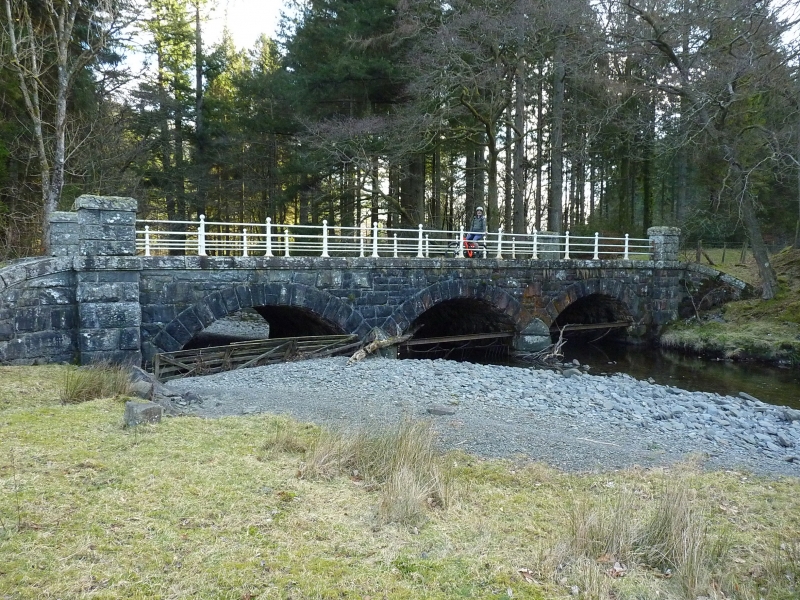
This bridge is marked on the Ordnance Survey map of 1887, and may be the first of the series of bridges of various designs constituting a set on the 17-km Lake Vyrnwy perimeter road.
A low bridge of three spans of segmental form, in rock-faced masonry with voussoirs about 500 mm high. The keystones are not differentiated. Each span is about 5 m.
The carriageway is about 6 m wide between the handrails; these consist of steel or iron rails on cast-iron standards on stone plinths, terminating with rusticated ashlar piers and copings. The cast-iron standards are of square section with ball-finials, chamfers and enlarged feet.
One of a set of bridges, in various monumental styles and evidently designed by different hands, related to the exploitation of the Reservoir perimeter road for its touristic potential, and closely related to the management of the Reservoir estate.
External links are from the relevant listing authority and, where applicable, Wikidata. Wikidata IDs may be related buildings as well as this specific building. If you want to add or update a link, you will need to do so by editing the Wikidata entry.


Other nearby listed buildings
