Approximate Location Map
Large Map »
Latitude: 52.7694 / 52°46'9"N
Longitude: -3.4566 / 3°27'23"W
OS Eastings: 301824
OS Northings: 320079
OS Grid: SJ018200
Mapcode National: GBR 6L.YLT9
Mapcode Global: WH67T.WN59
Plus Code: 9C4RQG9V+P9
Entry Name: Pont Cynon
Listing Date: 26 February 2003
Last Amended: 26 February 2003
Grade: II
Source: Cadw
Source ID: 80933
Building Class: Transport
ID on this website: 300080933
Location: On the north lakeside road 0.6 km from the Vyrnwy Dam.
County: Powys
Community: Llanwddyn
Community: Llanwddyn
Locality: Lake Vyrnwy
Traditional County: Montgomeryshire
Tagged with: Bridge Road bridge
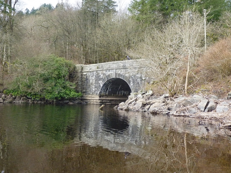
Pont Cynon (over the Afon y dolau gwynion), also known as Boat-house bridge, is the closest of the set of bridges on the 17-km Vyrnwy perimeter road to the reservoir, and its design appears to have been the object of greater architectural attention. It appears to have been built c.1890. The lowest reach of the river above the bridge is navigable to small boars when the reservoir is full, for which purpose there is a landing stage.
Before the flooding of the valley, there was an earlier Pont Cynon near the confluence of this stream with the River Vyrnwy.
The bridge is of high elliptical section, with a span of about 12 m; the interior of the arch is of brick but the facing each side is of slate. The slate facing returns considerably into the intrados. Voussoirs with roughly pecked finish, integrated into the common stone coursing; tall keystone hanging from the string course at the parapet base. Prominent string course with chiselled margins at the base of the parapet and at the springing line of the arch. Very large stone below the latter string course. Many of the stones show quarry drill marks and lewis holes.
One of a set of bridges, in various monumental styles and evidently designed by different hands, related to the exploitation of the Reservoir perimeter road for its touristic potential, and closely related to the management of the Reservoir estate.
External links are from the relevant listing authority and, where applicable, Wikidata. Wikidata IDs may be related buildings as well as this specific building. If you want to add or update a link, you will need to do so by editing the Wikidata entry.


Other nearby listed buildings
