History in Structure

Milestone near Tanrhallt

A Grade II Listed Building in Llanrhaeadr-ym-Mochnant, Powys

More Photos »
Approximate Location Map
Large Map »

Coordinates

Latitude: 52.8326 / 52°49'57"N

Longitude: -3.3159 / 3°18'57"W

OS Eastings: 311443

OS Northings: 326929

OS Grid: SJ114269

Mapcode National: GBR 6R.TR03

Mapcode Global: WH78V.1289

Plus Code: 9C4RRMMM+2J

Entry Name: Milestone near Tanrhallt

Listing Date: 29 August 2003

Last Amended: 29 August 2003

Grade: II

Source: Cadw

Source ID: 81833

Building Class: Transport

ID on this website: 300081833

Location: At the east side of Waterfall Road, about 1 km north-west of the village of Llanrhaeadr-ym-Mochnant.

County: Powys

Community: Llanrhaeadr-ym-Mochnant

Community: Llanrhaeadr-ym-Mochnant

Locality: Waterfall Road

Traditional County: Denbighshire

Tagged with: Milestone

Find accommodation in
Llanrhaeadr-ym-Mochnant

History

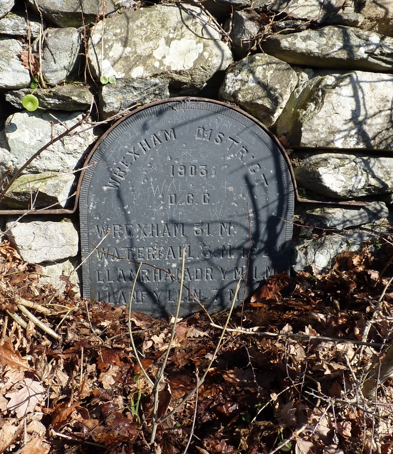
Erected by Denbighshire County Council in 1903.

Exterior

A slate milestone about 600 mm wide and 50 mm thick, rounded at the top and given a decorative machined edging. The stone is set into a stone wall. The top of the stone is protected and secured by an iron strip the tails of which are built into the masonry.

The wording on the milestone is 'Wrexham District / 1903 / D.C.C. / Wrexham 31 M / Waterfall 3 M 1 F 2 CH / Llanrhaiadr Y M 1 M / Llanfyllin 7 M'.

Reasons for Listing

One of a set of fine machine-carved slate milestones erected by Denbighshire County Council on Waterfall Road.

External Links

External links are from the relevant listing authority and, where applicable, Wikidata. Wikidata IDs may be related buildings as well as this specific building. If you want to add or update a link, you will need to do so by editing the Wikidata entry.

Recommended Books

Other nearby listed buildings

  • II Former cruck house in Tan-y-ffordd farmyard
    At the north corner of the west range of farm buildings associated with Tan-y-ffordd Ochor farmhouse.
  • II* Henfache
    To the north of the farmyard of Henfache, about 1 km north of the village of Llanrhaeadr-ym-Mochnant.
  • II Bryn Tirion
    At the east side of Waterfall Road, on high ground.
  • II Castle Building
    In the west part of the village of Llanrhaeadr-ym-Mochnant, beside a minor road to Cefn-coch.
  • II The Waterloo Stone
    In a field at north side of the village street and west of the River Rhaeadr, reached by a private passage at the side of New Mills.
  • II Arwelfa
    At the west side of Waterfall Road.
  • II Bodawel
    At the west side of Waterfall Road.
  • II Bwthyn-hedd
    At the west side of open space in the village of Llanrhaeadr-ym-Mochnant, about 100 m west of the bridge.

BritishListedBuildings.co.uk is an independent online resource and is not associated with any government department. All government data published here is used under licence. Please do not contact BritishListedBuildings.co.uk for any queries related to any individual listed building, planning permission related to listed buildings or the listing process itself.

British Listed Buildings is a Good Stuff website.