Approximate Location Map
Large Map »
Latitude: 51.7098 / 51°42'35"N
Longitude: -4.9512 / 4°57'4"W
OS Eastings: 196201
OS Northings: 205351
OS Grid: SM962053
Mapcode National: GBR G7.V9YL
Mapcode Global: VH1S0.49B3
Plus Code: 9C3QP25X+WG
Entry Name: The War Memorial
Listing Date: 26 February 2004
Last Amended: 26 February 2004
Grade: II
Source: Cadw
Source ID: 82530
Building Class: Commemorative
Also known as: The War Memorial
ID on this website: 300082530
Location: Facing N in the centre of Kensington Road some 25m S of its junction with the High Street.
County: Pembrokeshire
Town: Milford Haven
Community: Neyland
Community: Neyland
Built-Up Area: Neyland
Traditional County: Pembrokeshire
Tagged with: War memorial
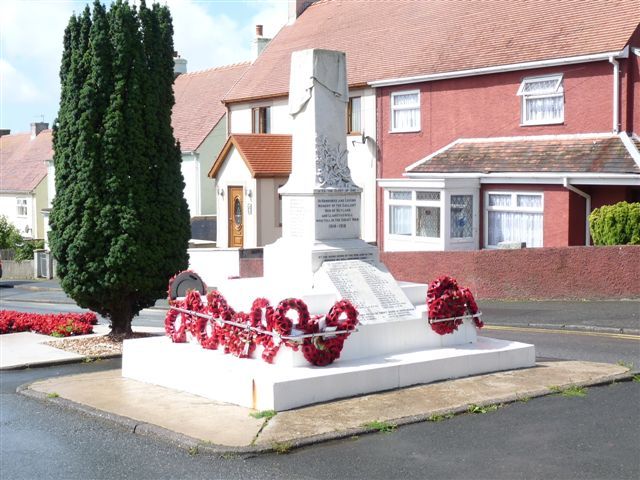
War Memorial unveiled in December 1930 to the First World War dead of Neyland and Llanstadwell, the number reflecting the population at the end of the era of the Irish ferries, transferred to Fishguard c1906. An added tablet records the dead of World War 2.
War memorial, white marble truncated short obelisk with draped top. Carved relief at foot of oak leaves and broken cannon. Coved plinth, set on square pedestal itself on square base. Inscriptions on pedestal, 'TO THE GLORY OF GOD', 'IN HONOURED AND LOVING MEMORY OF THE GALLANT MEN OF NEYLAND AND LLANSTADWELL WHO FELL IN THE GREAT WAR 1914-18', and 'AT THE GOING DOWN OF THE SUN, AND IN THE MORNING WE WILL REMEMBER THEM'. Ten names are recorded on the right side of the pedestal, 11 names to the left and 12 names to the rear. The monument was raised, probably later, on 3 whitewashed steps, with sloping tablet in front, partly obscuring inscription on base of original memorial. The tablet has the inscription 'IN MEMORY OF THOSE KNOWN TO HAVE LOST THEIR LIVES IN CONNECTION WITH WORLD WAR 2' followed by 38 names. Below is 'CIVILIANS KILLED BY ENEMY BOMB IN HAZELBANK' followed by 4 names.
Included as a marble war memorial of historical interest.
External links are from the relevant listing authority and, where applicable, Wikidata. Wikidata IDs may be related buildings as well as this specific building. If you want to add or update a link, you will need to do so by editing the Wikidata entry.


Other nearby listed buildings
