History in Structure

Station House

A Grade II Listed Building in Neyland, Pembrokeshire

More Photos »
Approximate Location Map
Large Map »

Coordinates

Latitude: 51.706 / 51°42'21"N

Longitude: -4.9459 / 4°56'45"W

OS Eastings: 196551

OS Northings: 204913

OS Grid: SM965049

Mapcode National: GBR G7.VRB2

Mapcode Global: VH1S0.7D51

Plus Code: 9C3QP343+9J

Entry Name: Station House

Listing Date: 26 February 2004

Last Amended: 26 February 2004

Grade: II

Source: Cadw

Source ID: 82529

Building Class: Domestic

ID on this website: 300082529

Location: Facing Brunel Quay at the junction of Picton Road, High Street and Station Road.

County: Pembrokeshire

Town: Milford Haven

Community: Neyland

Community: Neyland

Built-Up Area: Neyland

Traditional County: Pembrokeshire

Tagged with: House

Find accommodation in
Pembroke Dock

History

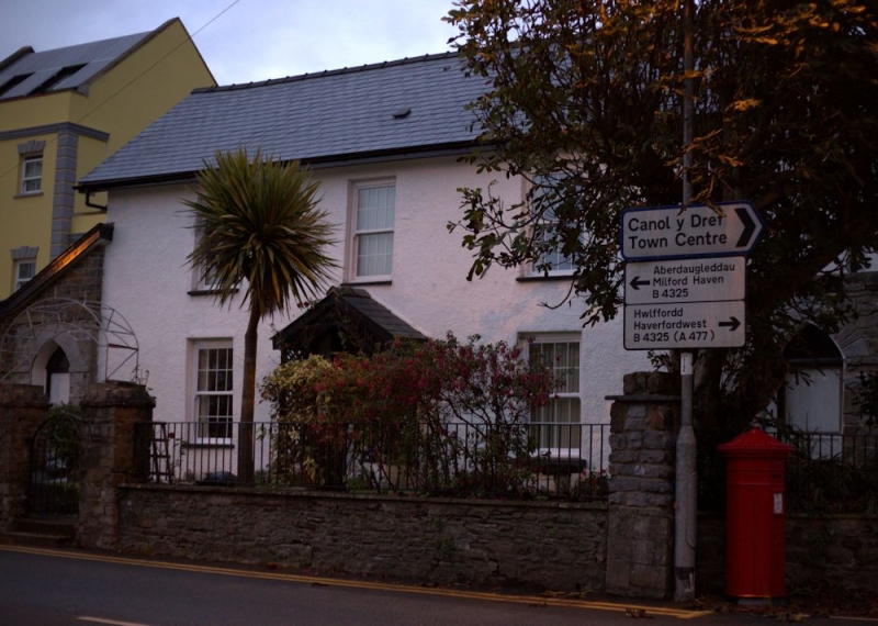
Built c1857 on site of Stag Inn, residence of station masters until closure of railway in 1964 when it became a private house.

Exterior

House, painted stucco with slate deep eaved roof and red brick end stacks, left stack missing. Two-storey, 3-window broad facade with large 16-pane sashes and centre door with overlight set in gabled trellis porch. Attached on each end is a Gothic pointed doorway with cut stone voussoirs and raised string course above, left doorway built into added lean-to, right doorway with coping stones over arch.

Interior

Not inspected.

Reasons for Listing

Included as a well-designed mid C19 house, the most significant single building surviving of the Brunel railway town.

External Links

External links are from the relevant listing authority and, where applicable, Wikidata. Wikidata IDs may be related buildings as well as this specific building. If you want to add or update a link, you will need to do so by editing the Wikidata entry.

Recommended Books

Other nearby listed buildings

  • II Pillar Box near Station House
    On the N side of the junction of Picton Road, High Street and Station Road just E of Station House
  • II The War Memorial
    Facing N in the centre of Kensington Road some 25m S of its junction with the High Street.
  • II Lime kiln at Church Lake
    Built into the valley side on the W side of Neyland some 400m E of the Church of Saint Tudwal at Llanstadwell.
  • II Two Bollards on N Side of Quay
    The 2 bollards are situated some 30m N and NW of Public Toilets at Hobbs Point. The cannon bollard is sited immediately N of Old Pier House, and set below pavement level.
  • II One Former Cannon Barrel to SW Side
    The 2 bollards are situated some 30m N and NW of Public Toilets at Hobbs Point. The cannon bollard is sited immediately N of Old Pier House, and set below pavement level.
  • II Slipway & Quay Wall at Hobb's Point
    Situated at N end of Pier Road and forming the most northerly part of Hobbs Point.
  • II Hobbs Point
    The 2 bollards are situated some 30m N and NW of Public Toilets at Hobbs Point. The cannon bollard is sited immediately N of Old Pier House, and set below pavement level.
  • II Pembroke Haven Yacht Club at Hobbs Point
    Situated on S side of quay, at NE corner of Pier Road opposite Old Pier House.

BritishListedBuildings.co.uk is an independent online resource and is not associated with any government department. All government data published here is used under licence. Please do not contact BritishListedBuildings.co.uk for any queries related to any individual listed building, planning permission related to listed buildings or the listing process itself.

British Listed Buildings is a Good Stuff website.