Approximate Location Map
Large Map »
Latitude: 52.9477 / 52°56'51"N
Longitude: -3.9979 / 3°59'52"W
OS Eastings: 265858
OS Northings: 340794
OS Grid: SH658407
Mapcode National: GBR 5W.L7BN
Mapcode Global: WH55N.K5GK
Plus Code: 9C4RW2X2+3R
Entry Name: Ty'r Felin
Listing Date: 25 February 2005
Last Amended: 25 February 2005
Grade: II
Source: Cadw
Source ID: 84025
Building Class: Agriculture and Subsistence
ID on this website: 300084025
Location: Set alongside the NW side of the A487(T) in the centre of the small hamlet of Tan-y-bwlch.
County: Gwynedd
Community: Maentwrog
Community: Maentwrog
Locality: Tan-y-bwlch
Traditional County: Merionethshire
Tagged with: Architectural structure
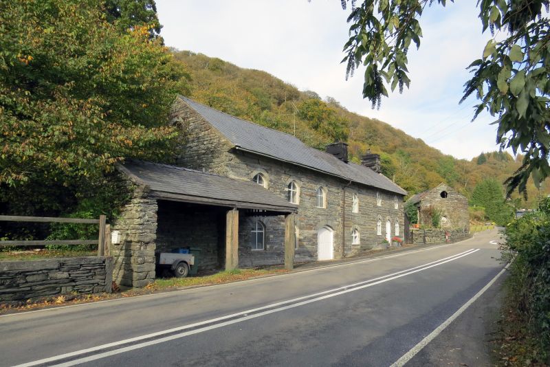
Mid to late C19 corn mill and mill house. The mill and kiln house were not marked on the tithe map of the parish, 1840, though agricultural buildings may not have been annotated and these formed ancillary buildings to the Tan-y-bwlch estate, at that time owned and occupied by Louisa Jane Oakeley. They are known to have been in place and working, with power derived from the millpond above, before Llyn Mair was created in the 1880s.
William Gruffyd Oakeley (1790-1835) was only 21 when he inherited the Plas Tan-y-bwlch estate and set about an ambitious programme of improving the estate. This entailed new building in the village of Maentwrog and rebuilding or improving the existing buildings. In order to do so he opened a quarry near Gelli Grin from which was quarried the large lengths of brown stone present in so many of the village buildings. The buildings probably utilised Gelli Grin stone, but may have been built after William Gruffydd's time.
Two storey mill house and former cornmill in alignment, with open fronted storage building at SW corner. Built of coursed and dressed local stone; slate roof with overhanging eaves and verges and stone stacks with dripstones and capping to either end of the mill house. The house is a 2-window range with central doorway, all openings in pointed arched openings with stone voussoirs; the door is boarded and the windows are timber casements, first floor windows directly under the eaves. The mill is a 4-window range with the doorway offset to the R (E) end; openings are similar but at a lower level and there is a circular window in the W gable apex. At the SW corner of the mill is an open fronted storage area of 2 bays on monolithic stone piers; the rear and W wall built of rubble masonry and the slate roof has stone coping at the W end.
The interior was not inspected at the time of the survey (June/July 2003).
Listed as a little altered C19 mill and mill house with good estate character, that forms a group with the adjacent mill and mill house at Tan-y-bwlch.
External links are from the relevant listing authority and, where applicable, Wikidata. Wikidata IDs may be related buildings as well as this specific building. If you want to add or update a link, you will need to do so by editing the Wikidata entry.


Other nearby listed buildings
