Approximate Location Map
Large Map »
Latitude: 51.6759 / 51°40'33"N
Longitude: -4.9175 / 4°55'2"W
OS Eastings: 198381
OS Northings: 201494
OS Grid: SM983014
Mapcode National: GBR G8.WDVP
Mapcode Global: VH1S6.Q45K
Plus Code: 9C3QM3GM+92
Entry Name: Pembroke House
Listing Date: 29 July 2005
Last Amended: 29 July 2005
Grade: II
Source: Cadw
Source ID: 84985
Building Class: Commercial
ID on this website: 300084985
Location: Next to the Town Hall on the S side of Main Street some 65m E of its junction with Northgate Street.
County: Pembrokeshire
Town: Pembroke
Community: Pembroke (Penfro)
Community: Pembroke
Built-Up Area: Pembroke
Traditional County: Pembrokeshire
Tagged with: House
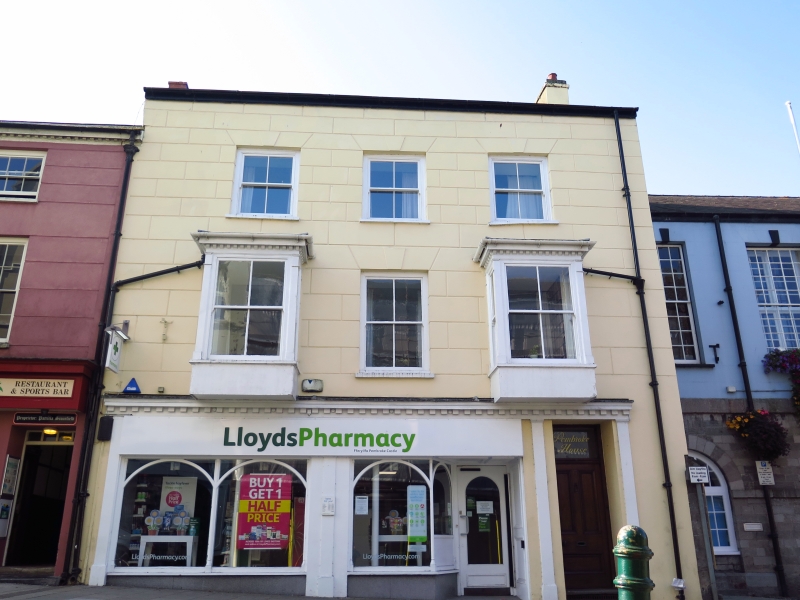
Town house, probably early C19 altered in later C19. Ground floor shop refronted c. 2000 for Alliance & Leicester Bank. An old photograph shows the facade without the timber oriel windows.
Terraced house, taller than No 17 to E and Town Hall to W, which is set back. Painted stucco, lined as ashlar with close eaved slate roof and end stacks, brick to left, rendered to right. Three storeys, three-window range. Three 4-pane horned sashes to top floor and one longer to first floor centre, with incised keystone and voussoirs. Painted slate sills. Outer windows of first floor have been replaced by later C19 square oriels with moulded cornices, angle pilasters and 2-4-2-pane sashes. Plain renewed bases.
Ground floor altered in later C20. Original house doorway to right, not aligned, with hardwood 3-panel door and overlight. Late C20 shopfront in two wide bays, the entry recessed in right bay. Thin dentil cornice over, continued over house door.
Rendered right end wall. Rear has scattered fenestration, mostly C20 and C20 flat-roofed single-storey additions.
Ground floor altered, upper floors not inspected.
Included for its special architectural interest as a substantial town house, of group value with the Town Hall.
External links are from the relevant listing authority and, where applicable, Wikidata. Wikidata IDs may be related buildings as well as this specific building. If you want to add or update a link, you will need to do so by editing the Wikidata entry.


Other nearby listed buildings
