Approximate Location Map
Large Map »
Latitude: 51.8128 / 51°48'46"N
Longitude: -2.7138 / 2°42'49"W
OS Eastings: 350889
OS Northings: 212929
OS Grid: SO508129
Mapcode National: GBR FL.WTR3
Mapcode Global: VH86T.XP6N
Plus Code: 9C3VR77P+4F
Entry Name: Brecon House
Listing Date: 10 August 2005
Last Amended: 10 August 2005
Grade: II
Source: Cadw
Source ID: 85161
Building Class: Domestic
ID on this website: 300085161
Location: On the street continuing Church Street east out of the town centre.
County: Monmouthshire
Town: Monmouth
Community: Monmouth (Trefynwy)
Community: Monmouth
Built-Up Area: Monmouth
Traditional County: Monmouthshire
Tagged with: House
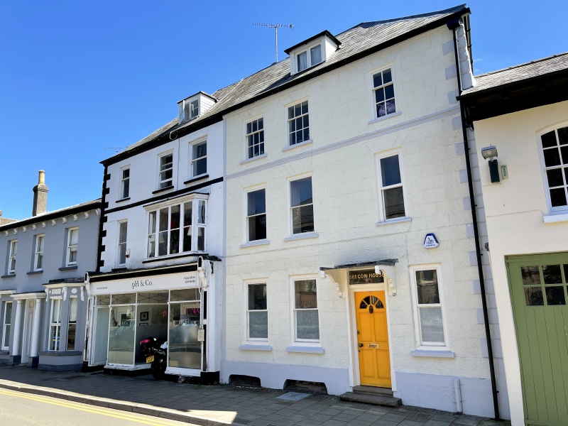
Early C18 house pair, probably c1725, with alterations in c1900.
Doorway with late C20 panelled door with integral fanlight, transom light, flat hood on shaped brackets. Windows are all plate glass sashes in unaltered openings except top floor ones which are 3 over 6 pane sashes with one 2 over 4.
The rear elevation as a ground floor extension, C20 casement windows and a sloping topped dormer.
The narrow half bay to the right of the door holds the early C18 stair with straight flights, closed string, turned balusters, square newel, moulded handrail and dado panelling opposite. Other contemporary joinery includes dado panelling, a keyed archway in the hall and a shell head cupboard with shaped shelves; there are also 2-panel doors and early C18 floorboards. The interior has also been fairly altered at various times.
Included for its special architectural interest as one of an early C18 pair of houses of definite character which is part of the important group of historic buildings near St. Mary's Church.
External links are from the relevant listing authority and, where applicable, Wikidata. Wikidata IDs may be related buildings as well as this specific building. If you want to add or update a link, you will need to do so by editing the Wikidata entry.


Other nearby listed buildings
