Latitude: 51.8151 / 51°48'54"N
Longitude: -2.6991 / 2°41'56"W
OS Eastings: 351905
OS Northings: 213169
OS Grid: SO519131
Mapcode National: GBR FL.WYZ1
Mapcode Global: VH86V.5MGX
Plus Code: 9C3VR882+29
Entry Name: Dixton Lodge
Listing Date: 10 August 2005
Last Amended: 10 August 2005
Grade: II
Source: Cadw
Source ID: 85193
Building Class: Domestic
ID on this website: 300085193
Location: On a lane leading north from May Hill along the east bank of the River Wye.
County: Monmouthshire
Town: Monmouth
Community: Monmouth (Trefynwy)
Community: Monmouth
Locality: Hadnock
Built-Up Area: Monmouth
Traditional County: Monmouthshire
Tagged with: Gatehouse
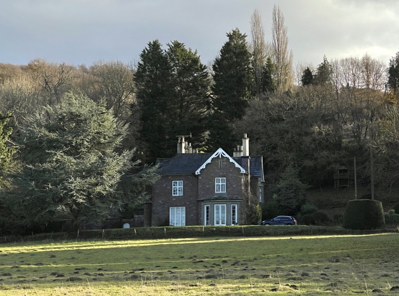
Built in 1870 as the Rectory for St. Peter's, Dixton and possibly designed by J P Seddon who was restoring the parish church at that time. It is now a private house.
Built of coursed red sandstone rubble with some ashlar dressings, Welsh slate roofs with ashlar stacks. Tudor Gothic style with an informal plan. Two storeys, three bay entrance (west) front. This has a gabled bay to the left and the entrance in the centre. Windows with Tudor arched lights and a 4-centred doorway. Gable with fretted bargeboards and tall triple-flued stack with diamond set shafts to right. The garden (north) elevation is two bays with a projecting gabled wing to right. On the left is a tall tripartite French casement with small paned windows, above this a 2-light mullion-and-transom window. The gabled wing has a canted stone bay covering the whole of the ground floor. This has French doors and side windows with marginal glazing and a slated roof. The first floor has a 2-light window as before. Slit vent in the gable, fretted bargeboards. Roof hipped to left, three more 2 and 3-flued stacks behind.
Rear elevation not seen.
Interior not available at resurvey.
Included for its special architectural interest as a Victorian rectory of definite character designed possibly by J P Seddon.
External links are from the relevant listing authority and, where applicable, Wikidata. Wikidata IDs may be related buildings as well as this specific building. If you want to add or update a link, you will need to do so by editing the Wikidata entry.


Other nearby listed buildings