Approximate Location Map
Large Map »
Latitude: 51.7452 / 51°44'42"N
Longitude: -2.9482 / 2°56'53"W
OS Eastings: 334628
OS Northings: 205587
OS Grid: SO346055
Mapcode National: GBR J7.1C3M
Mapcode Global: VH79M.VD7H
Plus Code: 9C3VP3W2+3P
Entry Name: Chain Bridge (partly in Gwehelog Fawr community)
Listing Date: 31 January 2000
Last Amended: 9 December 2005
Grade: II
Source: Cadw
Source ID: 87147
Building Class: Transport
ID on this website: 300087147
Location: Situated on the B4598 Abergavenny to Usk road, bridging the Usk just north of the Chain Bridge Inn. The bridge is partly in Gwehelog Fawr Community.
County: Monmouthshire
Town: Abergavenny
Community: Llanover (Llanofer)
Community: Llanover
Locality: Llanfair Kilgeddin
Traditional County: Monmouthshire
Tagged with: Bridge
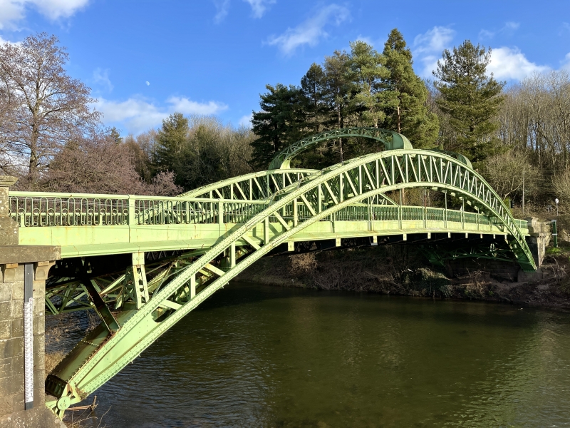
Road bridge over the River Usk built 1905-6 (dated). A plaque records that it was opened on 26/7/1906, J J Webster MICE Engineer, William Tanner FSI County Surveyor, George Palmer of Neath, Contractor. A second plaque records that it was repaired in 1999 by Monmouthshire County Council. The bridge replaced a suspension bridge of c1830 and still retains the original name.
Painted steel single arch bridge with paired bowstring lattice girder arches from which iron rods descend to carry fish bellied pierced iron girders under road deck. The two bowed trusses are connected over the roadway by two lattice girder spans. Decorative iron rails with moulded plinth, square posts, oval and circle pattern rails and moulded handrail. End rubblestone piers with dentilled cornices and caps, commemorative bronze panels fixed to west piers. Short length of coped squared rubblestone wall at each end. The very altered tollhouse from the previous bridge remains at the Llanover end of the bridge.
Included for its special interest as an impressive example of early C20 bridge building technology that is also a fairly rare example of a bowstring girder road bridge.
External links are from the relevant listing authority and, where applicable, Wikidata. Wikidata IDs may be related buildings as well as this specific building. If you want to add or update a link, you will need to do so by editing the Wikidata entry.


Other nearby listed buildings
