Approximate Location Map
Large Map »
Latitude: 53.1103 / 53°6'37"N
Longitude: -3.3259 / 3°19'33"W
OS Eastings: 311343
OS Northings: 357832
OS Grid: SJ113578
Mapcode National: GBR 6R.82M1
Mapcode Global: WH77G.W2FX
Plus Code: 9C5R4M6F+4M
Entry Name: Churchyard boundary walls, including East Lychgate, at Church of St Mwrog
Listing Date: 30 December 2005
Last Amended: 30 December 2005
Grade: II
Source: Cadw
Source ID: 87323
ID on this website: 300087323
Location: The Church of St Mwrog and its churchyard are located on top of a hill, the ground falling steeply to the N into a river valley, and a road running along the S side.
County: Denbighshire
Town: Ruthin
Community: Ruthin (Rhuthun)
Community: Ruthin
Locality: Llanfwrog
Built-Up Area: Ruthin
Traditional County: Denbighshire
Tagged with: Lychgate
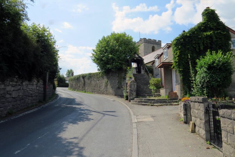
The churchyard boundary walls are shown in their current form on the Ordnance Survey of 1874. The curvilinear wall on the S side is in its original location; the W wall is said to be part of an extension to the churchyard; the W and N walls are retaining walls, and may have been straightened in the past. There are lychgates to the SW and to the SE. The latter is probably mid-C19, built to imitate the earlier SW lychgate, and possibly replacing an earlier lychgate on this site: an entrance is marked here on an 1826 plan of Ruthin.
High stone wall to S, fronting the road, constructed of large blocks of random stone, with intermittent random stones forming coping. To W and N sides, high battered retaining wall of random stone supported by raked buttresses. On the W side, the top of the wall is partly coped in concrete, and steps down towards the N. The W and N walls are surmounted by narrow iron railings. The E boundary is mainly demarcated by a building not associated with the church.
The E lychgate is half-timbered on a high stone plinth under a slate roof. Gabled entrances, the external E front reached by steep stone steps. Segmental-arched entrance, the lintel supported on timber posts. The lintel is also a collar which may be earlier and re-used from elsewhere; it bears an inscription in Welsh. The gable has a vertical strut and a finial. Timber boarding flanking entrance. The W front is weather-boarded with wide entrance which has a shallow segmental-arched head. The sides of the porch have a single band of open timber panels, over a high plinth. Plain rafter roof inside. Attached to the E entrance is a cast iron gate with bands of circles beneath the top rail and lock rail, fleur-de-lis finials and decorative dog-rails.
Listed as churchyard boundary walls and lychgate retaining their historic character, the S wall possibly with early origins. Group value with Church of St Mwrog and associated structures.
External links are from the relevant listing authority and, where applicable, Wikidata. Wikidata IDs may be related buildings as well as this specific building. If you want to add or update a link, you will need to do so by editing the Wikidata entry.


Other nearby listed buildings
