History in Structure

Fountain near Marble Church

A Grade II Listed Building in Bodelwyddan, Denbighshire

More Photos »
Approximate Location Map
Large Map »

Coordinates

Latitude: 53.2667 / 53°16'0"N

Longitude: -3.497 / 3°29'49"W

OS Eastings: 300256

OS Northings: 375462

OS Grid: SJ002754

Mapcode National: GBR 4Z0N.QP

Mapcode Global: WH65H.841Z

Plus Code: 9C5R7G83+M6

Entry Name: Fountain near Marble Church

Listing Date: 10 August 2007

Last Amended: 10 August 2007

Grade: II

Source: Cadw

Source ID: 87542

Building Class: Civil

ID on this website: 300087542

Location: On N side of former St Asaph road now by-passed by A55; on corner with road to hospital.

County: Denbighshire

Town: Rhyl

Community: Bodelwyddan

Community: Bodelwyddan

Locality: The Village

Built-Up Area: Bodelwyddan

Traditional County: Flintshire

Tagged with: Fountain

Find accommodation in
Kinmel

History

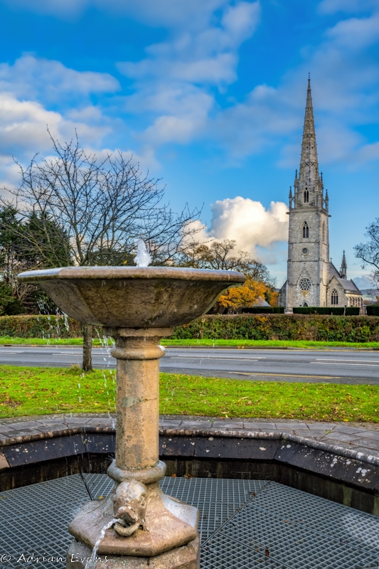
On OS map of 1878, and probably contemporary with the nearby Marble Church, Vicarage and Village housing, circa 1857. Perhaps by John Gibson, architect of the church, vicarage and village housing. The fountain was fed by pipes from ponds behind Bodelwyddan Castle, but the supply was cut when the dual carriageway was built in the 1980s. Restored early C21.

Exterior

Fountain in grey stone similar to that of adjacent Marble Church. Bowl supported by column with dolphin heads on octagonal base. Set within octagonal stone basin with moulded copings.

Reasons for Listing

Listed for Group Value with the listed buildings including the Marble Church, Vicarage, School and listed buildings of the Village.

External Links

External links are from the relevant listing authority and, where applicable, Wikidata. Wikidata IDs may be related buildings as well as this specific building. If you want to add or update a link, you will need to do so by editing the Wikidata entry.

Recommended Books

Other nearby listed buildings

  • II Bodelwyddan Village Hall (former School)
    In Bodelwyddan Village, opposite the Vicarage.
  • II Bodelwyddan Vicarage
    To E of Bodelwyddan village, on a site corner to corner with St Margaret's churchyard. Gate and steps link to churchyard.
  • II Churchyard Wall of St Margaret's
    Forming a rectangular enclosure to St Margaret's churchyard. Timber gates at SW and small iron gate at NW (to vicarage). Small breach at NE corner gives access to an additional graveyard.
  • II 18, The Village
    To the W side of the street of Bodelwyddan Village, opposite the Vicarage, in 2 terraces; shared front access paths behind low stone wall; shared rear paths.
  • II 17, The Village
    To the W side of the street of Bodelwyddan Village, opposite the Vicarage, in 2 terraces; shared front access paths behind low stone wall; shared rear paths.
  • II 16, The Village
    To the W side of the street of Bodelwyddan Village, opposite the Vicarage, in 2 terraces; shared front access paths behind low stone wall; shared rear paths.
  • II 15, The Village
    To the W side of the street of Bodelwyddan Village, opposite the Vicarage, in 2 terraces; shared front access paths behind low stone wall; shared rear paths.
  • II 14, The Village
    To the W side of the street of Bodelwyddan Village, opposite the Vicarage, in 2 terraces; shared front access paths behind low stone wall; shared rear paths.

BritishListedBuildings.co.uk is an independent online resource and is not associated with any government department. All government data published here is used under licence. Please do not contact BritishListedBuildings.co.uk for any queries related to any individual listed building, planning permission related to listed buildings or the listing process itself.

British Listed Buildings is a Good Stuff website.