History in Structure

Churchyard Wall of St Margaret's

A Grade II Listed Building in Bodelwyddan, Denbighshire

More Photos »
Approximate Location Map
Large Map »

Coordinates

Latitude: 53.2665 / 53°15'59"N

Longitude: -3.4955 / 3°29'43"W

OS Eastings: 300349

OS Northings: 375433

OS Grid: SJ003754

Mapcode National: GBR 4Z1N.0R

Mapcode Global: WH65H.85P5

Plus Code: 9C5R7G83+JQ

Entry Name: Churchyard Wall of St Margaret's

Listing Date: 6 December 2002

Last Amended: 6 December 2002

Grade: II

Source: Cadw

Source ID: 80739

ID on this website: 300080739

Location: Forming a rectangular enclosure to St Margaret's churchyard. Timber gates at SW and small iron gate at NW (to vicarage). Small breach at NE corner gives access to an additional graveyard.

County: Denbighshire

Community: Bodelwyddan

Community: Bodelwyddan

Locality: The Village

Built-Up Area: Bodelwyddan

Traditional County: Flintshire

Tagged with: Churchyard wall

Find accommodation in
Kinmel

History

Probably built c1860, at the time of the completion of St Margaret''''s church to the design of John Gibson.

Exterior

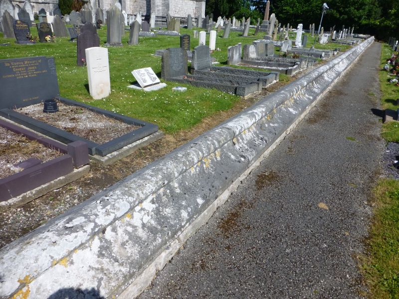
A very low wall in local limestone with a moulded coping, surrounding the churchyard of St Margaret. Stone gatepiers at main entrace at SW corner. Flight of steps to gate leading to vicarage at NW corner. On the S side the churchyard is adjacent to and level with the pavement of the road. On the W side the adjacent field has a ditch against the wall, creating a ha-ha on this side only. Elsewhere the adjacent land is at a lower level than the churchyard.

The main gatepiers are at the SW corner. Tall stone piers with chamfered arrises and gabled copings; timber gates.

Reasons for Listing

Listed for group value with St Margaret''''s church.

External Links

External links are from the relevant listing authority and, where applicable, Wikidata. Wikidata IDs may be related buildings as well as this specific building. If you want to add or update a link, you will need to do so by editing the Wikidata entry.

Recommended Books

Other nearby listed buildings

  • II* Church of St Margaret (The Marble Church)
    At N side of the former St Asaph road now bypassed by the adjacent A55. Low perimeter wall separately listed.
  • II Fountain near Marble Church
    On N side of former St Asaph road now by-passed by A55; on corner with road to hospital.
  • II Bodelwyddan Vicarage
    To E of Bodelwyddan village, on a site corner to corner with St Margaret's churchyard. Gate and steps link to churchyard.
  • II Bodelwyddan Village Hall (former School)
    In Bodelwyddan Village, opposite the Vicarage.
  • II 18, The Village
    To the W side of the street of Bodelwyddan Village, opposite the Vicarage, in 2 terraces; shared front access paths behind low stone wall; shared rear paths.
  • II 17, The Village
    To the W side of the street of Bodelwyddan Village, opposite the Vicarage, in 2 terraces; shared front access paths behind low stone wall; shared rear paths.
  • II 16, The Village
    To the W side of the street of Bodelwyddan Village, opposite the Vicarage, in 2 terraces; shared front access paths behind low stone wall; shared rear paths.
  • II 15, The Village
    To the W side of the street of Bodelwyddan Village, opposite the Vicarage, in 2 terraces; shared front access paths behind low stone wall; shared rear paths.

BritishListedBuildings.co.uk is an independent online resource and is not associated with any government department. All government data published here is used under licence. Please do not contact BritishListedBuildings.co.uk for any queries related to any individual listed building, planning permission related to listed buildings or the listing process itself.

British Listed Buildings is a Good Stuff website.