Approximate Location Map
Large Map »
Latitude: 52.245 / 52°14'41"N
Longitude: 0.7142 / 0°42'51"E
OS Eastings: 585396
OS Northings: 264224
OS Grid: TL853642
Mapcode National: GBR QF0.7D7
Mapcode Global: VHKD4.BTFW
Plus Code: 9F426PV7+XM
Entry Name: 16 and 16A, Abbeygate Street
Listing Date: 12 July 1972
Last Amended: 30 October 1997
Grade: II
Source: Historic England
Source ID: 1021959
English Heritage Legacy ID: 466583
ID on this website: 101021959
Location: Bury St Edmunds, West Suffolk, IP33
County: Suffolk
District: West Suffolk
Civil Parish: Bury St Edmunds
Built-Up Area: Bury St Edmunds
Traditional County: Suffolk
Lieutenancy Area (Ceremonial County): Suffolk
Church of England Parish: Bury St Edmunds St John the Evangelist
Church of England Diocese: St.Edmundsbury and Ipswich
Tagged with: Building
BURY ST EDMUNDS
TL8564SW ABBEYGATE STREET
639-1/14/127 (North side)
12/07/72 Nos.16 AND 16A
(Formerly Listed as:
ABBEYGATE STREET
No.16)
GV II
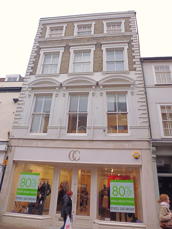
Offices of the Trustee Savings Bank, formerly a house and
shop. c1863, designed by William Spanton, photographer, for
his own use. No.16A is the Area Office of the TSB, which
occupies the upper floors of both No.16 and No.17 (qv). White
brick and slates.
EXTERIOR: 4 storeys: this is the highest building in the
street. Stucco cornice and moulded rusticated quoins. 3 sash
windows to the top storey with vertical glazing bars and
stucco shouldered architraves. A raised band at sill level. 3
sash windows to the 2nd storey with single vertical glazing
bars, shouldered architraves and cornices. The first storey is
stuccoed and the 3 sash windows have moulded architraves and
segmental pediments on console brackets. The ground storey has
a plain C20 shop front.
INTERIOR: an original steep winder stair in the north-east
corner of No.16, which runs the whole height of the building,
has bracketed open strings, slender column balusters, and a
wreathed handrail.
Listing NGR: TL8539664224
External links are from the relevant listing authority and, where applicable, Wikidata. Wikidata IDs may be related buildings as well as this specific building. If you want to add or update a link, you will need to do so by editing the Wikidata entry.


Other nearby listed buildings
