Approximate Location Map
Large Map »
Latitude: 52.2438 / 52°14'37"N
Longitude: 0.7141 / 0°42'50"E
OS Eastings: 585397
OS Northings: 264089
OS Grid: TL853640
Mapcode National: GBR QF0.7CL
Mapcode Global: VHKD4.BVDT
Plus Code: 9F426PV7+GM
Entry Name: 18 and 18A, Hatter Street
Listing Date: 7 August 1952
Grade: II
Source: Historic England
Source ID: 1022531
English Heritage Legacy ID: 466901
ID on this website: 101022531
Location: Bury St Edmunds, West Suffolk, IP33
County: Suffolk
District: West Suffolk
Civil Parish: Bury St Edmunds
Built-Up Area: Bury St Edmunds
Traditional County: Suffolk
Lieutenancy Area (Ceremonial County): Suffolk
Church of England Parish: Bury St Edmunds St Mary
Church of England Diocese: St.Edmundsbury and Ipswich
Tagged with: Building
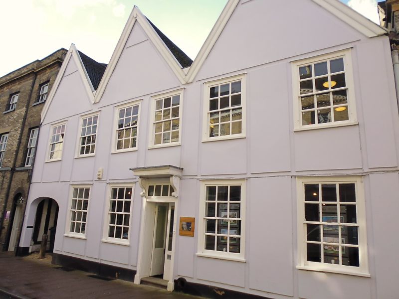
BURY ST EDMUNDS
TL8564SW HATTER STREET
639-1/14/426 (West side)
07/08/52 Nos.18 AND 18A
GV II
House, now offices. C16 and C17 with early C18 alterations and
extensions. Timber-framed; rendered in panels; plaintiled
roof.
EXTERIOR: 2 storeys and cellar. Roof with 3 gables facing the
street; a wide arched entrance at the south end with exposed
timbering along its side walls. 6 window range: 12-pane sashes
to each storey in flush cased frames with thick early C18
ovolo-moulded glazing-bars. A central entrance door has a
doorcase with a flat pediment supported by heavy scrolled
brackets; plain reveals; door with 2 leaves and a fanlight
with vertical glazing-bars.
INTERIOR: rubble and stone to the cellar walls; ceiling
supported by a heavy chamfered main beam and flat joists.
Above ground, the oldest part of the building is the wide
entrance at the south end and the room above it, which have
heavy studding and are separately framed in 3 bays with
possible indications of a medieval core.
The remainder of the front range has extensive early C18
changes and has been extended at the rear, where there is a
fine stair and balustrade with closed strings, barley-sugar
twist balusters, plain newels and moulded handrail. Panelled
dado. In both the front upper rooms corner fireplaces with
bolection-moulded surrounds have been introduced.
A narrower C17 rear range of 2 storeys and attics, has a
plaintiled mansard roof and is faced with ornate Edwardian
tile-hanging. 2 rooms to each storey: on the ground storey one
room has full height panelling with raised mouldings and a
heavy moulded wooden cornice. Bolection moulded fireplace
surround with plain pilasters and heavy cornice projecting
slightly above. The 1st storey room has a C17 main beam with
scroll-stops. A C19 extension to the west of the rear range
has a shallow-pitched roof and is also tile-hung.
Listing NGR: TL8539764089
External links are from the relevant listing authority and, where applicable, Wikidata. Wikidata IDs may be related buildings as well as this specific building. If you want to add or update a link, you will need to do so by editing the Wikidata entry.


Other nearby listed buildings
