Approximate Location Map
Large Map »
Latitude: 52.2438 / 52°14'37"N
Longitude: 0.7141 / 0°42'50"E
OS Eastings: 585397
OS Northings: 264099
OS Grid: TL853640
Mapcode National: GBR QF0.7CK
Mapcode Global: VHKD4.BVDR
Plus Code: 9F426PV7+GM
Entry Name: 19, Hatter Street
Listing Date: 12 July 1972
Grade: II
Source: Historic England
Source ID: 1022532
English Heritage Legacy ID: 466902
ID on this website: 101022532
Location: Bury St Edmunds, West Suffolk, IP33
County: Suffolk
District: West Suffolk
Civil Parish: Bury St Edmunds
Built-Up Area: Bury St Edmunds
Traditional County: Suffolk
Lieutenancy Area (Ceremonial County): Suffolk
Church of England Parish: Bury St Edmunds St Mary
Church of England Diocese: St.Edmundsbury and Ipswich
Tagged with: Building
BURY ST EDMUNDS
TL8564SW HATTER STREET
639-1/14/427 (West side)
12/07/72 No.19
GV II
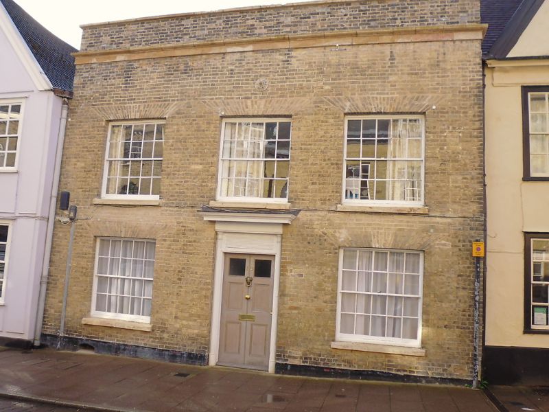
House, now a restaurant with living accommodation above. Late
C17 with an early C19 front. Timber-framed; fronted in painted
brick with a plain parapet and stucco cornice. Plaintiled
roof.
EXTERIOR: 2 storeys; 2 timber-framed wings at rear. 3 window
range: 20-pane sashes in plain reveals with projecting stone
sills and wide gauged flat arches. A recessed doorway with
slender fluted engaged columns and a blank rectangular
fanlight has a fully glazed C20 door. The rear wings are both
rendered with plaintiled roofs.
INTERIOR: appears to consist of 2 separate frames, on the
right forming a wing. All beams boxed in on the ground storey,
in the bay to the left of the entry also with plaster
mouldings and a plaster cornice. The shorter wing on the left
of the rear has a stair with dumbbell balusters and a moulded
handrail but is apparently mainly Edwardian in date, although
containing some C17 components.
Listing NGR: TL8539764099
External links are from the relevant listing authority and, where applicable, Wikidata. Wikidata IDs may be related buildings as well as this specific building. If you want to add or update a link, you will need to do so by editing the Wikidata entry.


Other nearby listed buildings
