Approximate Location Map
Large Map »
Latitude: 52.2437 / 52°14'37"N
Longitude: 0.7002 / 0°42'0"E
OS Eastings: 584443
OS Northings: 264053
OS Grid: TL844640
Mapcode National: GBR QDZ.9TV
Mapcode Global: VHKD4.3V0T
Plus Code: 9F426PV2+F3
Entry Name: Cemetery Chapel
Listing Date: 30 October 1997
Grade: II
Source: Historic England
Source ID: 1022583
English Heritage Legacy ID: 466953
ID on this website: 101022583
Location: Bury St Edmunds, West Suffolk, IP33
County: Suffolk
District: West Suffolk
Civil Parish: Bury St Edmunds
Built-Up Area: Bury St Edmunds
Traditional County: Suffolk
Lieutenancy Area (Ceremonial County): Suffolk
Church of England Parish: Bury St Edmunds St Mary
Church of England Diocese: St.Edmundsbury and Ipswich
Tagged with: Chapel
BURY ST EDMUNDS
TL86 KING'S ROAD
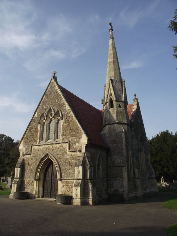
639-1/13/465 Cemetery Chapel
II
Chapel. 1855. The survivor of 2 chapels, one for Anglicans and
one for Nonconformists, designed by Mr Peck of Cooper & Peck
of No.1 Furnivall's Inn, London. Faced in coursed stone blocks
of Kentish ragstone with freestone dressings; plaintiled roofs
with ornamental ridge-tiles. Early English style.
EXTERIOR: nave and chancel with 2 very short transepts; a
small square turret, with octagonal top stage and a spirelet,
is attached to the south side of the nave in the angle with
the south transept. Roll-moulded stone sills. West entrance
with multiple mouldings to the pointed arch and an outer
keeled hood-mould with foliated bosses. A keeled stone band at
impost level continues round the side walls below the
window-sills. A further stepped band below the 3-light west
window. All the windows are 3-light with cusped tracery,
pointed hood-moulds and foliated bosses. Angle buttresses to
the east and west ends, diagonal buttresses to the transepts.
INTERIOR: not inspected.
Listing NGR: TL8444364053
External links are from the relevant listing authority and, where applicable, Wikidata. Wikidata IDs may be related buildings as well as this specific building. If you want to add or update a link, you will need to do so by editing the Wikidata entry.


Other nearby listed buildings
