Latitude: 52.2461 / 52°14'46"N
Longitude: 0.7179 / 0°43'4"E
OS Eastings: 585646
OS Northings: 264363
OS Grid: TL856643
Mapcode National: GBR QF0.2BQ
Mapcode Global: VHKD4.DSDZ
Plus Code: 9F426PW9+F5
Entry Name: The Dutch House
Listing Date: 7 August 1952
Last Amended: 30 October 1997
Grade: II
Source: Historic England
Source ID: 1022609
English Heritage Legacy ID: 466979
ID on this website: 101022609
Location: Bury St Edmunds, West Suffolk, IP33
County: Suffolk
District: West Suffolk
Civil Parish: Bury St Edmunds
Built-Up Area: Bury St Edmunds
Traditional County: Suffolk
Lieutenancy Area (Ceremonial County): Suffolk
Church of England Parish: Bury St Edmunds St John the Evangelist
Church of England Diocese: St.Edmundsbury and Ipswich
Tagged with: House
BURY ST EDMUNDS
TL8564SE MUSTOW STREET
639-1/8/482 (North side)
07/08/52 The Dutch House
(Formerly Listed as:
MUSTOW STREET
(North side)
No.1A
and Mustow House)
GV II
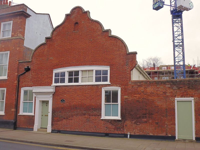
House, formerly part of Mustow House (qv). Early C19. Red
brick front, rendered sides; plaintiled roof. Set sideways-on
to the street with an elaborately shaped Dutch gable.
EXTERIOR: 2 storeys; 2 sash windows in flush cased frames to
the ground storey, one with a single vertical bar to lights,
the other with 2 vertical bars. On the upper storey, paired
C20 windows have been set into a wider recessed opening,
partly blocked, with a shallow segmental brick arch. Entrance
door with flush panels in a moulded wood architrave with a
flat bracketed pediment. Modernised interior. Included for
group value with Mustow House (qv).
Listing NGR: TL8563064358
External links are from the relevant listing authority and, where applicable, Wikidata. Wikidata IDs may be related buildings as well as this specific building. If you want to add or update a link, you will need to do so by editing the Wikidata entry.


Other nearby listed buildings