Approximate Location Map
Large Map »
Latitude: 51.0663 / 51°3'58"N
Longitude: -1.797 / 1°47'49"W
OS Eastings: 414323
OS Northings: 129681
OS Grid: SU143296
Mapcode National: GBR 51F.2HS
Mapcode Global: FRA 7639.KRP
Plus Code: 9C3W3683+G6
Entry Name: 25, the Close
Listing Date: 28 February 1952
Grade: II*
Source: Historic England
Source ID: 1023603
English Heritage Legacy ID: 319000
ID on this website: 101023603
Location: The Friary, Wiltshire, SP1
County: Wiltshire
Civil Parish: Salisbury
Built-Up Area: Salisbury
Traditional County: Wiltshire
Lieutenancy Area (Ceremonial County): Wiltshire
Tagged with: Building
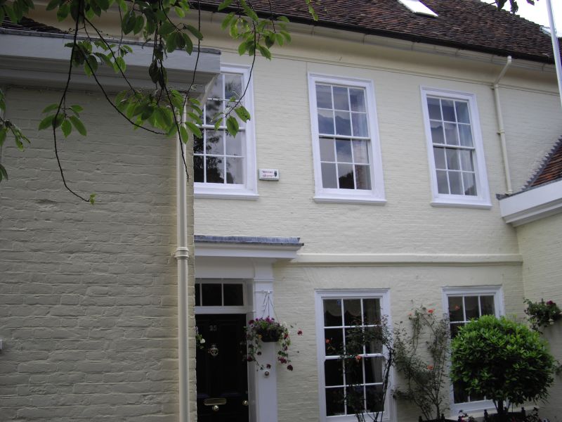
THE CLOSE
1.
1594
No 25
SU 1429 NW 3/36 28.2.52.
II* GV
2.
Originally 2 houses. C14 but recased C17/C18. 2 storeys colour washed brick
on projecting plinth. Moulded string to 1st floor. Steep pitch hipped old
tile roof with moulded and coved eaves cornice. 3 windows grouped in centre
on 1st floor. 2 windows on ground floor. Flush architrave framed sashes,
glazing bars intact. Modern door with early C19 surround of pilasters and
cornice hood under left hand window. Flanking 1 storey wings, similar design
but with coping above cornice, hipped roofs. The northern half of house contains
a C14 stair and in the southern part is a Jacobean staircase.
All the listed buildings in the Close form an outstanding group.
Listing NGR: SU1432429683
External links are from the relevant listing authority and, where applicable, Wikidata. Wikidata IDs may be related buildings as well as this specific building. If you want to add or update a link, you will need to do so by editing the Wikidata entry.


Other nearby listed buildings
