Approximate Location Map
Large Map »
Latitude: 51.3553 / 51°21'18"N
Longitude: -1.672 / 1°40'19"W
OS Eastings: 422939
OS Northings: 161850
OS Grid: SU229618
Mapcode National: GBR 5Z7.XTM
Mapcode Global: VHC22.Y6ZD
Plus Code: 9C3W984H+46
Entry Name: 63 and 65, High Street
Listing Date: 13 June 1988
Grade: II
Source: Historic England
Source ID: 1035914
English Heritage Legacy ID: 312233
ID on this website: 101035914
Location: Westcourt, Wiltshire, SN8
County: Wiltshire
Civil Parish: Burbage
Built-Up Area: Burbage
Traditional County: Wiltshire
Lieutenancy Area (Ceremonial County): Wiltshire
Tagged with: Building Thatched cottage
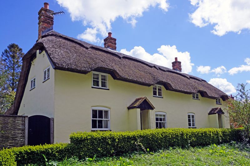
BURBAGE HIGH STREET
SU 26 SW (east side)
2/24 Nos 63 and 65
II
Two attached cottages. Probably C16, much altered. Roughcast on
timber framing, thatched roof. Two storeys, each of 2 bays with
central C20 door in open gabled porch. Timber casement windows.
No 63 at north end has narrow outshut along rear under extension of
roof. Three tall brick stacks. Interior not seen. Believed to
contain cruck construction.
Listing NGR: SU2293961850
External links are from the relevant listing authority and, where applicable, Wikidata. Wikidata IDs may be related buildings as well as this specific building. If you want to add or update a link, you will need to do so by editing the Wikidata entry.


Other nearby listed buildings
