Latitude: 52.2448 / 52°14'41"N
Longitude: 0.7127 / 0°42'45"E
OS Eastings: 585296
OS Northings: 264202
OS Grid: TL852642
Mapcode National: GBR QF0.707
Mapcode Global: VHKD4.9VN0
Plus Code: 9F426PV7+W3
Entry Name: The Nutshell Public House
Listing Date: 12 July 1972
Last Amended: 30 October 1997
Grade: II
Source: Historic England
Source ID: 1038277
English Heritage Legacy ID: 467592
Also known as: The Nutshell, Bury St. Edmunds
The Nutshell
ID on this website: 101038277
Location: Bury St Edmunds, West Suffolk, IP33
County: Suffolk
District: West Suffolk
Civil Parish: Bury St Edmunds
Built-Up Area: Bury St Edmunds
Traditional County: Suffolk
Lieutenancy Area (Ceremonial County): Suffolk
Church of England Parish: Bury St Edmunds St John the Evangelist
Church of England Diocese: St.Edmundsbury and Ipswich
Tagged with: Pub
BURY ST EDMUNDS
TL8564SW THE TRAVERSE 639-1/14/641 No.17 12/07/72 The Nutshell Public House (Formerly Listed as: THE TRAVERSE (East side) No.17 The Nutshell Inn)
GV II
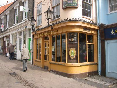
Public house. Mid C19. Timber-framed and rendered; slate roof with a wide plain eaves cornice. 3 storeys and cellar; 2 windows to each storey facing the Traverse and one to each storey of the return (south) front: all sashes in flush cased frames, 12-pane to the 1st storey and 9-pane to the 2nd storey. The corner is rounded and the mullioned shop front to the ground storey is carried round both sides with pilasters and frieze and a cornice surmounted by an ornate cast-iron cresting. INTERIOR: a single room to each storey; no evidence of an earlier core. This is claimed to be the smallest public house in England.
Listing NGR: TL8529664202
External links are from the relevant listing authority and, where applicable, Wikidata. Wikidata IDs may be related buildings as well as this specific building. If you want to add or update a link, you will need to do so by editing the Wikidata entry.


Other nearby listed buildings