Approximate Location Map
Large Map »
Latitude: 52.245 / 52°14'41"N
Longitude: 0.7131 / 0°42'46"E
OS Eastings: 585318
OS Northings: 264224
OS Grid: TL853642
Mapcode National: GBR QF0.73G
Mapcode Global: VHKD4.9TTV
Plus Code: 9F426PV7+X6
Entry Name: 4, 5 and 6, Buttermarket
Listing Date: 12 July 1972
Grade: II
Source: Historic England
Source ID: 1031124
English Heritage Legacy ID: 466670
ID on this website: 101031124
Location: Bury St Edmunds, West Suffolk, IP33
County: Suffolk
District: West Suffolk
Civil Parish: Bury St Edmunds
Built-Up Area: Bury St Edmunds
Traditional County: Suffolk
Lieutenancy Area (Ceremonial County): Suffolk
Church of England Parish: Bury St Edmunds St John the Evangelist
Church of England Diocese: St.Edmundsbury and Ipswich
Tagged with: Building
TL8564SW
639-1/14/210
12/07/72
BURY ST EDMUNDS
BUTTERMARKET
(West side)
Nos.4, 5 AND 6
GV
II
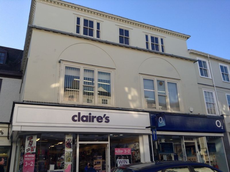
2 shops with storage above. Early C19. Timber-framed and
rendered; slate roof with modillion eaves cornice.
3 storeys and cellar; stands forward with 2 fronts. The 2nd
storey projects slightly on both fronts with a modillion
soffit under the overhang. Above the 1st storey is a cornice
with mutules. The 2nd storey has a 3 window range with the 2
outer windows 3-light, all late C19 sashes with a single
vertical bar to lights. The 1st storey has C20 3-light windows
in slightly-recessed semicircular arches. C20 shop fronts to
the ground storey.
Listing NGR: TL8531864224
External links are from the relevant listing authority and, where applicable, Wikidata. Wikidata IDs may be related buildings as well as this specific building. If you want to add or update a link, you will need to do so by editing the Wikidata entry.


Other nearby listed buildings
