Approximate Location Map
Large Map »
Latitude: 53.3413 / 53°20'28"N
Longitude: -0.899 / 0°53'56"W
OS Eastings: 473403
OS Northings: 383277
OS Grid: SK734832
Mapcode National: GBR QY5S.5Y
Mapcode Global: WHFG9.585T
Plus Code: 9C5X84R2+GC
Entry Name: The Old Vicarage
Listing Date: 1 February 1967
Grade: II
Source: Historic England
Source ID: 1045691
English Heritage Legacy ID: 241469
ID on this website: 101045691
Location: Clarborough, Bassetlaw, Nottinghamshire, DN22
County: Nottinghamshire
District: Bassetlaw
Civil Parish: Clarborough and Welham
Built-Up Area: Clarborough
Traditional County: Nottinghamshire
Lieutenancy Area (Ceremonial County): Nottinghamshire
Church of England Parish: Clarborough
Church of England Diocese: Southwell and Nottingham
Tagged with: Clergy house
This list entry was subject to a Minor Amendment on 11 April 2023 to reformat the text to current standards
SK 78 SW
4/3
CLARBOROUGH
CHURCH LANE (east side)
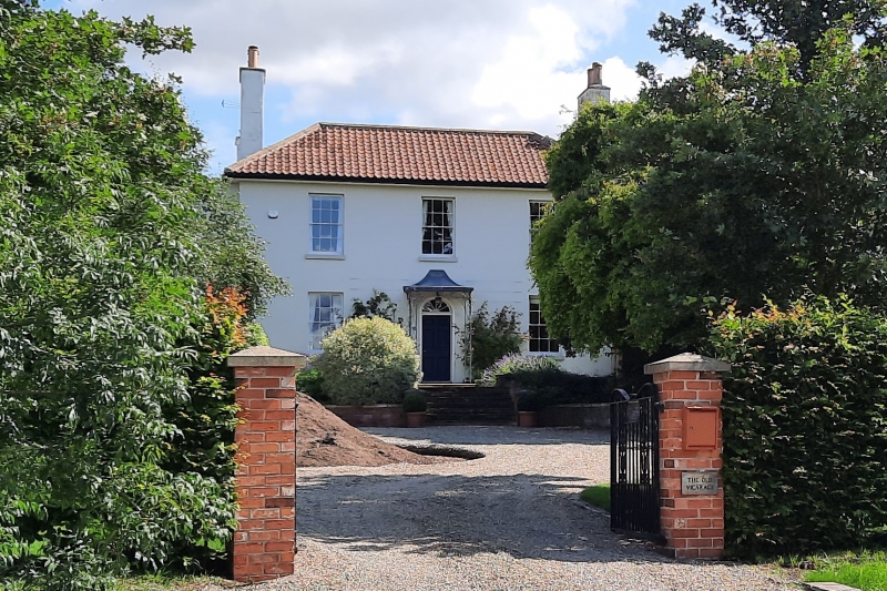
The Old Vicarage
1.2.67
G.V.
II
Vicarage, now house. c.1820. Brick with coloured rendering. Hipped C20 pantile roof. Two storeys, four bays, three side wall stacks, square plan with two storey lean-to addition to left. Main south front has C20 flat roofed porch with plastic columns and round headed doorway with panelled door and fanlight. Flanked by single glazing bar sashes and beyond, to left, a glazing bar casement. Above, to left, a single glazing bar casement and three glazing bar sashes.
Listing NGR: SK7340383277
External links are from the relevant listing authority and, where applicable, Wikidata. Wikidata IDs may be related buildings as well as this specific building. If you want to add or update a link, you will need to do so by editing the Wikidata entry.


Other nearby listed buildings
