Approximate Location Map
Large Map »
Latitude: 51.7576 / 51°45'27"N
Longitude: -1.2605 / 1°15'37"W
OS Eastings: 451138
OS Northings: 206809
OS Grid: SP511068
Mapcode National: GBR 8YY.L5D
Mapcode Global: VHCXV.32HX
Plus Code: 9C3WQP5Q+3R
Entry Name: 41, St Giles Street
Listing Date: 12 January 1954
Grade: II*
Source: Historic England
Source ID: 1047144
English Heritage Legacy ID: 245838
ID on this website: 101047144
Location: Norham Manor, Oxford, Oxfordshire, OX1
County: Oxfordshire
District: Oxford
Electoral Ward/Division: Carfax
Parish: Non Civil Parish
Built-Up Area: Oxford
Traditional County: Oxfordshire
Lieutenancy Area (Ceremonial County): Oxfordshire
Church of England Parish: Oxford St Giles
Church of England Diocese: Oxford
Tagged with: Building
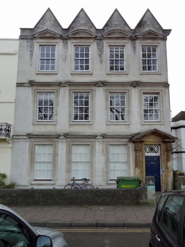
ST GILES' STREET
1.
1485
(West Side)
No 41
SP 5106 NW 5/512 12.1.54.
II* GV
2.
House. RCHM 18O. Circa 1700. 3-storeyed ashlar front with 4 gables,
refaced 1956. The ground floor has 3 sash windows in moulded stone frames
with moulded cornices. The front doorway to the North has two engaged Doric
columns, entablature, a split pediment and a rectangular fanlight. The four
sash windows in the 1st and 2nd floors have moulded cornices and the two
outside windows in the latter floor have triangular pediments, while the
two inside ones have segmental pediments. At the back the North West wing
is probably contemporary and is partly timber-framed. Interior: Contemporary
staircase with close strings square newels and turned balusters. There
are some early Cl9 door frames.
Nos 3l to 46 (consec) and Nos 49 to 56 (consec) form a group.
Listing NGR: SP5114406792
External links are from the relevant listing authority and, where applicable, Wikidata. Wikidata IDs may be related buildings as well as this specific building. If you want to add or update a link, you will need to do so by editing the Wikidata entry.


Other nearby listed buildings
