Approximate Location Map
Large Map »
Latitude: 51.7624 / 51°45'44"N
Longitude: -1.2106 / 1°12'38"W
OS Eastings: 454576
OS Northings: 207375
OS Grid: SP545073
Mapcode National: GBR 8Z0.DRF
Mapcode Global: VHCXN.YYVT
Plus Code: 9C3WQQ6Q+XQ
Entry Name: 1 and 2, North Place
Listing Date: 28 June 1972
Grade: II
Source: Historic England
Source ID: 1047203
English Heritage Legacy ID: 245698
ID on this website: 101047203
Location: Headington, Oxford, Oxfordshire, OX3
County: Oxfordshire
District: Oxford
Electoral Ward/Division: Headington
Parish: Non Civil Parish
Built-Up Area: Oxford
Traditional County: Oxfordshire
Lieutenancy Area (Ceremonial County): Oxfordshire
Church of England Parish: Headington St Andrew
Church of England Diocese: Oxford
Tagged with: Building
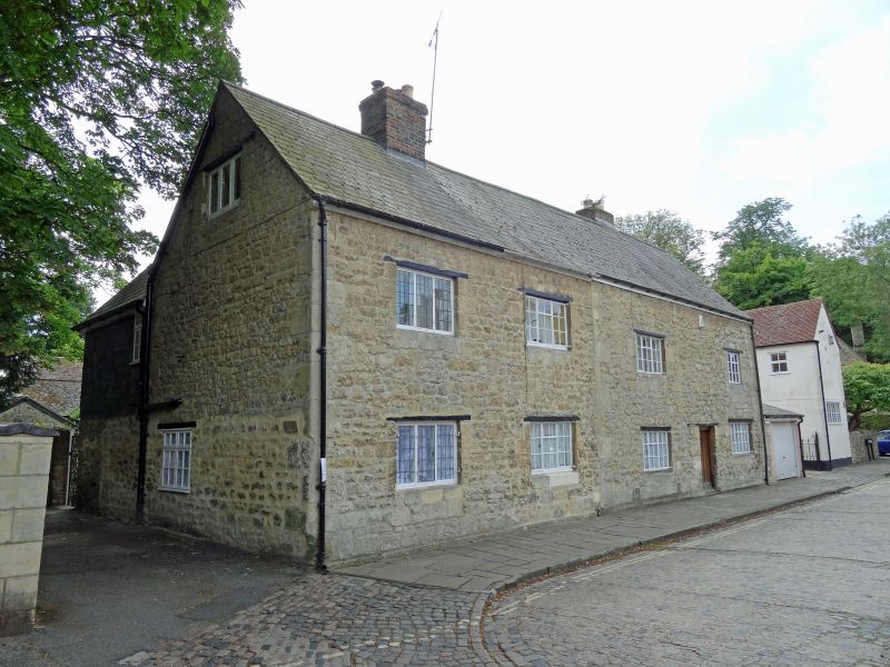
NORTH PLACE
1.
1485
Nos 1 & 2
SP 5407 18/60
II
2.
Cottages. 2 buildings. RCHM 270 and 271. Originally C17 2-storeyed rubble
with a Welsh slate roof. Stone-based stacks with modern brick shafts. The
South elevation has 2 gabled attic dormers. 2 windows each, 5-light metal
casement windows in wood frames and lintels. There are brick excrescences.
Listing NGR: SP5457607375
External links are from the relevant listing authority and, where applicable, Wikidata. Wikidata IDs may be related buildings as well as this specific building. If you want to add or update a link, you will need to do so by editing the Wikidata entry.


Other nearby listed buildings
