Approximate Location Map
Large Map »
Latitude: 51.7631 / 51°45'47"N
Longitude: -1.2106 / 1°12'38"W
OS Eastings: 454577
OS Northings: 207450
OS Grid: SP545074
Mapcode National: GBR 8Z0.DR6
Mapcode Global: VHCXN.YYW9
Plus Code: 9C3WQQ7Q+6Q
Entry Name: 69, Old High Street
Listing Date: 28 June 1972
Grade: II
Source: Historic England
Source ID: 1337673
English Heritage Legacy ID: 245701
ID on this website: 101337673
Location: Headington, Oxford, Oxfordshire, OX3
County: Oxfordshire
District: Oxford
Electoral Ward/Division: Headington
Parish: Non Civil Parish
Built-Up Area: Oxford
Traditional County: Oxfordshire
Lieutenancy Area (Ceremonial County): Oxfordshire
Church of England Parish: Headington St Andrew
Church of England Diocese: Oxford
Tagged with: Building
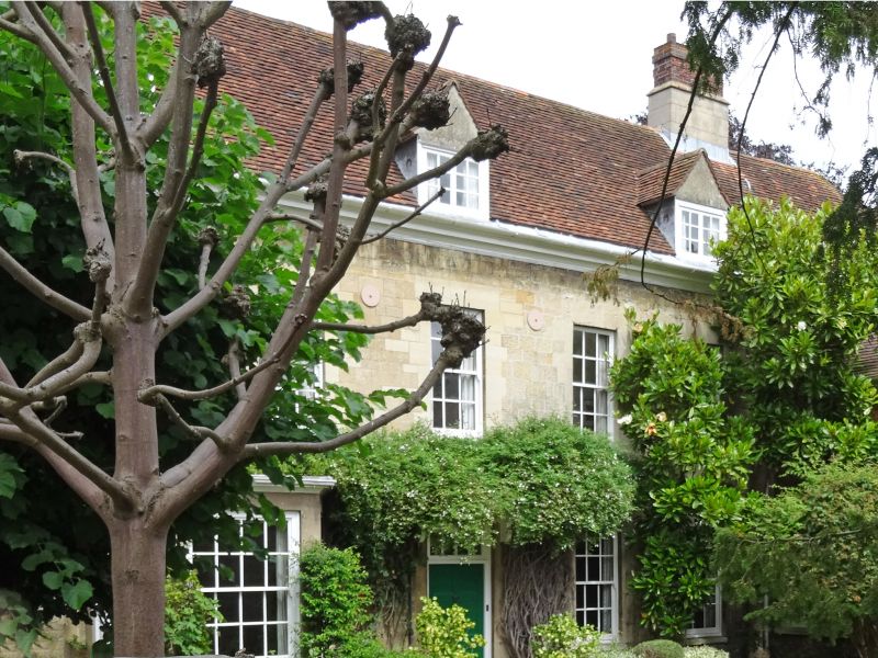
OLD HIGH STREET
1.
1485
(East Side)
No 69
SP 5407 18/58
II
2.
House. It may contain some C17 remains but the exterior appears to have
been remodelled in C18-C19. 2-storeyed ashlar in a long rectangular plan
at right angles to the road with a modern brick wing on South East. Moulded
eaves cornice and a red tiled roof in which are 4 gabled attic dormers with
2-light casement windows in them. The West gable has similar dormers. Cement-faced
stacks with brick shafts. 5 Cl8-C19 sash windows in plain stone reveals.
A modern flat hood to the front doorway.
Listing NGR: SP5457707450
External links are from the relevant listing authority and, where applicable, Wikidata. Wikidata IDs may be related buildings as well as this specific building. If you want to add or update a link, you will need to do so by editing the Wikidata entry.


Other nearby listed buildings
