Approximate Location Map
Large Map »
Latitude: 51.5762 / 51°34'34"N
Longitude: -0.9898 / 0°59'23"W
OS Eastings: 470104
OS Northings: 186857
OS Grid: SU701868
Mapcode National: GBR B2Y.2L8
Mapcode Global: VHDW6.SNM0
Plus Code: 9C3XH2G6+F3
Entry Name: 6, Watlington Street
Listing Date: 13 February 1985
Grade: II
Source: Historic England
Source ID: 1047386
English Heritage Legacy ID: 247137
ID on this website: 101047386
Location: Nettlebed, South Oxfordshire, RG9
County: Oxfordshire
District: South Oxfordshire
Civil Parish: Nettlebed
Built-Up Area: Nettlebed
Traditional County: Oxfordshire
Lieutenancy Area (Ceremonial County): Oxfordshire
Church of England Parish: Nettlebed with Highmoor
Church of England Diocese: Oxford
Tagged with: Building
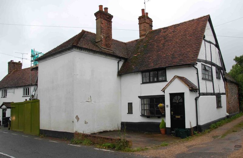
NETTLEBED WATLINGTON STREET
SU7068
(West side)
13/115 No.6
GV II
Cottage. C17 with C20 alterations. Rendered timber-framing; plain old tile
roof; brick stack. 2 storey, one-window range. C20 sash door to C20 flat-
roofed porch to right. C20 bow window on brackets to centre ground floor;
single window to left. 3-light C19 casement to 1st floor. Ridge stack to
left. Timber-frame with brick infill, with queen-post roof truss visible to
right return. Interior not inspected.
Listing NGR: SU7010486857
External links are from the relevant listing authority and, where applicable, Wikidata. Wikidata IDs may be related buildings as well as this specific building. If you want to add or update a link, you will need to do so by editing the Wikidata entry.


Other nearby listed buildings
