Approximate Location Map
Large Map »
Latitude: 51.5757 / 51°34'32"N
Longitude: -0.9907 / 0°59'26"W
OS Eastings: 470042
OS Northings: 186802
OS Grid: SU700868
Mapcode National: GBR B2Y.2CV
Mapcode Global: VHDW6.SN4D
Plus Code: 9C3XH2G5+7P
Entry Name: Robert Foulkes
Listing Date: 13 February 1985
Grade: II
Source: Historic England
Source ID: 1047378
English Heritage Legacy ID: 247120
ID on this website: 101047378
Location: Nettlebed, South Oxfordshire, RG9
County: Oxfordshire
District: South Oxfordshire
Civil Parish: Nettlebed
Built-Up Area: Nettlebed
Traditional County: Oxfordshire
Lieutenancy Area (Ceremonial County): Oxfordshire
Church of England Parish: Nettlebed with Highmoor
Church of England Diocese: Oxford
Tagged with: Building
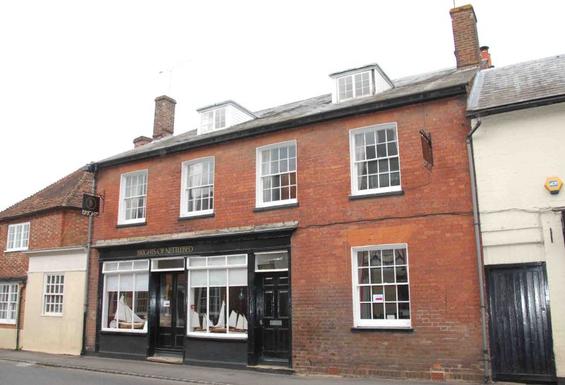
NETTLEBED HIGH STREET
SU7086
(North side)
13/98 No.22 (Robert Foulkes)
GV II
House, now shop. Late C18 with early C19 shop front. Red brick; slate roof;
brick stack. 2 storeys and attic; 4-window range. Shop front to left with
central double, glazed door; 6-panel door to right with overlight. 16-pane
sash window to right: Four 16-pane sashes to first floor. 2 flat-roofed C20
dormers. Internal stack to left. Interior not inspected.
Listing NGR: SU7005086802
External links are from the relevant listing authority and, where applicable, Wikidata. Wikidata IDs may be related buildings as well as this specific building. If you want to add or update a link, you will need to do so by editing the Wikidata entry.


Other nearby listed buildings
