Approximate Location Map
Large Map »
Latitude: 51.5974 / 51°35'50"N
Longitude: -1.1256 / 1°7'32"W
OS Eastings: 460661
OS Northings: 189091
OS Grid: SU606890
Mapcode National: GBR 911.XXJ
Mapcode Global: VHCYP.F3SR
Plus Code: 9C3WHVWF+XQ
Entry Name: 34, (The Manse) and 35, St Mary's Street
Listing Date: 9 December 1949
Last Amended: 9 February 1988
Grade: II
Source: Historic England
Source ID: 1048478
English Heritage Legacy ID: 249323
ID on this website: 101048478
Location: Wallingford, South Oxfordshire, OX10
County: Oxfordshire
District: South Oxfordshire
Civil Parish: Wallingford
Built-Up Area: Wallingford
Traditional County: Berkshire
Lieutenancy Area (Ceremonial County): Oxfordshire
Tagged with: Building
This list entry was subject to a Minor Amendment on 22/01/2018
SU6089SE
11/157
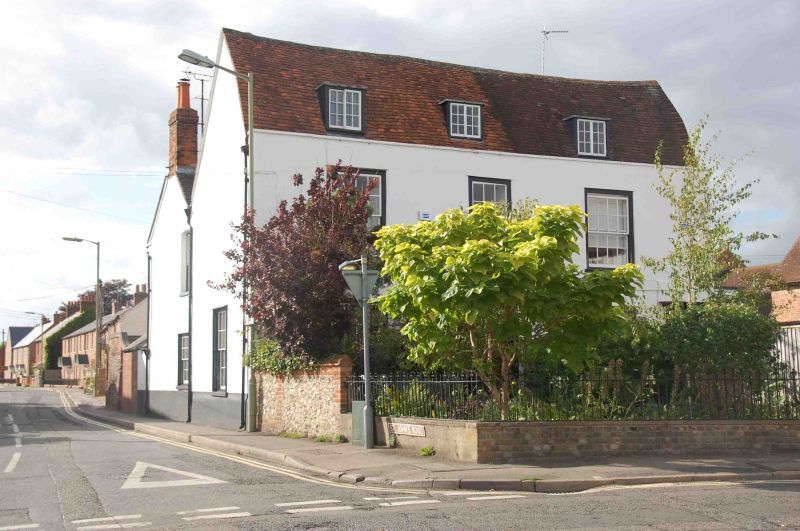
WALLINGFORD
ST MARY' STREET (West side)
Nos. 34 (The Manse) and 35
(Formerly listed as Nos. 34 (The Manse) and 55, previously listed as Nos.34 and 35)
09/12/49
GV
II
House, now two dwellings. Probably late C17 with C18 alterations. Render, probably on brick; old plain-tile gambrel roof; rendered stacks to rear. Two storeys and attic; three-window range. Six-panel door with decorative overlight arid pilaster strips to cornice at right. Sixteen-pane unhorned sashes with architrave surrounds to ground floor left, and to right of centre. Rendered flat band between ground and first floors. Twelve-pane unhorned sash with architrave surround to first floor centre, sixteen-pane unhorned sashes with architrave surrounds to left and right. Plain parapet to eaves. Three flat-roofed full dormers. Horizontal sash to left. Two-light wood casements to centre and right. Interior not inspected.
Listing NGR: SU6066189090
External links are from the relevant listing authority and, where applicable, Wikidata. Wikidata IDs may be related buildings as well as this specific building. If you want to add or update a link, you will need to do so by editing the Wikidata entry.


Other nearby listed buildings
