Approximate Location Map
Large Map »
Latitude: 53.1762 / 53°10'34"N
Longitude: -1.3114 / 1°18'40"W
OS Eastings: 446124
OS Northings: 364568
OS Grid: SK461645
Mapcode National: GBR 7C9.Z4F
Mapcode Global: WHDFQ.TFQD
Plus Code: 9C5W5MGQ+FF
Entry Name: The Grange
Listing Date: 23 March 1989
Grade: II
Source: Historic England
Source ID: 1052258
English Heritage Legacy ID: 79191
ID on this website: 101052258
Location: Ault Hucknall, Bolsover, Derbyshire, S44
County: Derbyshire
District: Bolsover
Civil Parish: Ault Hucknall
Traditional County: Derbyshire
Lieutenancy Area (Ceremonial County): Derbyshire
Church of England Parish: Ault Hucknall St John the Baptist
Church of England Diocese: Derby
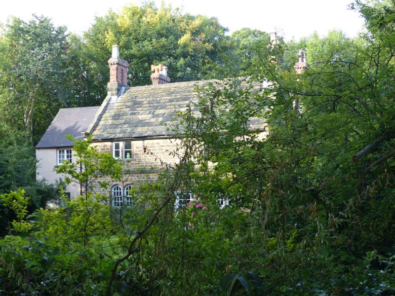
SK 46 SE PARISH OF AULT HUCKNALL OFF HODMIRE LANE
10/21 (South Side)
The Grange
II
House. C17,1724 and C19. Coursed squared sandstone with sandstone dressings and
quoins. Stone slate and machine tile roofs. Stone coped gables with moulded kneelers.
Stone and brick gable stacks with shafts in pairs and triplets, with chamfered angles
and dentil cornices. Two storeys. Double-fronted south elevation has a plain first
floor band and chamfered quoins at the south east corner. Off-centre doorway with
C20 glazed door and timber latticework porch. Flanked by paired 2-light windows, with
round-arched lights and glazing bar sashes. Two 2-light square section mullion
windows above. East elevation of two gabled bays, with chamfered quoins down the
middle. Central C20 glazed porch. Flanked on each side by two round-arched windows,
with bead moulded ashlar surrounds. Glazing bar sashes. Two 2-light square section
flush mullion windows above with glazing bar casements. Bead moulded ashlar
surrounds with basket arches. Moulded rectangular date panel above, in the left gable,
now illegible. The north elevation has two glazing bar sashes to each floor, set in
plain ashlar surrounds. Cement rendered range to west has plain 2 and 3-light
casements.
Listing NGR: SK4612464568
External links are from the relevant listing authority and, where applicable, Wikidata. Wikidata IDs may be related buildings as well as this specific building. If you want to add or update a link, you will need to do so by editing the Wikidata entry.


Other nearby listed buildings
