Approximate Location Map
Large Map »
Latitude: 51.9073 / 51°54'26"N
Longitude: -1.5786 / 1°34'42"W
OS Eastings: 429087
OS Northings: 223282
OS Grid: SP290232
Mapcode National: GBR 5RS.9QZ
Mapcode Global: VHBZF.LBB6
Plus Code: 9C3WWC4C+WH
Entry Name: Wayside Cross at Ngr SP 29082329
Listing Date: 27 August 1957
Last Amended: 15 May 1989
Grade: II*
Source: Historic England
Source ID: 1053279
English Heritage Legacy ID: 254090
ID on this website: 101053279
Location: Sarsden, West Oxfordshire, OX7
County: Oxfordshire
District: West Oxfordshire
Civil Parish: Sarsden
Traditional County: Oxfordshire
Lieutenancy Area (Ceremonial County): Oxfordshire
Church of England Parish: Churchill
Church of England Diocese: Oxford
Tagged with: Wayside cross
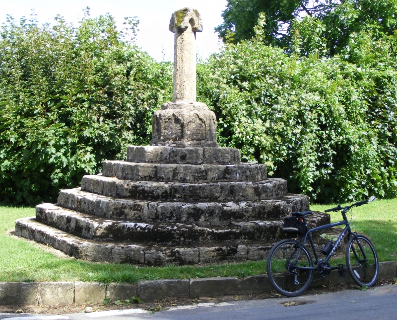
SARSDEN
SP22SE
7/195 Wayside cross at N.G.R. SP2908
2329
27.8.57 (Formerly listed as Cross)
GV II*
Not shown on O.S. map.
Wayside cross. Apparently early to mid-C14 but possibly early C19 reusing
medieval stonework. Limestone. Short octagonal shaft with gabled canopy having
small circular socket to top on octagonal plinth with blind cinquefoil-headed
panel to each side. Base of 6 wide steps forming irregular octagon. The cross is
not marked on detailed estate maps of the area made in 1788 and 1795 nor do the
accompanying terriers give any indication of its existence through field names.
The cross was drawn by J.C, Buckler in 1825, the year in which most of the old
church at Churchill (q.v.) was demolished, and it is possible that fragments
from there were used to make up the cross.
(Buildings of England: Oxfordshire: p753; B.J. Marples: The Medieval Crosses of
Oxfordshire: Oxoneinsia 38 (1973), pp.302, 303, 308; Bodleian Library, Oxford:
MS.Top.0xon.a.68 No.453; Oxfordshire County Record Office, estate maps)
[2645]
Listing NGR: SP2908723282
External links are from the relevant listing authority and, where applicable, Wikidata. Wikidata IDs may be related buildings as well as this specific building. If you want to add or update a link, you will need to do so by editing the Wikidata entry.


Other nearby listed buildings
