Latitude: 51.5514 / 51°33'5"N
Longitude: -1.1502 / 1°9'0"W
OS Eastings: 459019
OS Northings: 183957
OS Grid: SU590839
Mapcode National: GBR 91L.Q0K
Mapcode Global: VHCYW.08SJ
Plus Code: 9C3WHR2X+HW
Entry Name: The Bakery
Listing Date: 14 December 1977
Grade: II
Source: Historic England
Source ID: 1059264
English Heritage Legacy ID: 248012
ID on this website: 101059264
Location: Moulsford, South Oxfordshire, OX10
County: Oxfordshire
District: South Oxfordshire
Civil Parish: Moulsford
Built-Up Area: Moulsford
Traditional County: Berkshire
Lieutenancy Area (Ceremonial County): Oxfordshire
Tagged with: Building
MOULSFORD THE STREET
SU5985
(West side)
10/120
The Bakery
14/12/77
GV
II
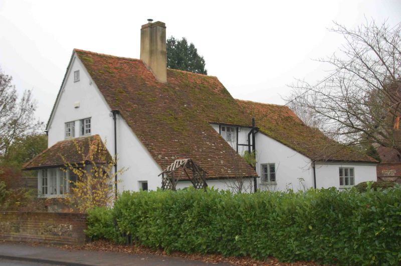
House, now shop and house. Probably mid C17 with later additions. Painted brick
to ground floor; large timber framing with painted brick infill to first floor;
old plain-tile roof; rendered central brick ridge stack. 2-storey, 2-bay ran<e
at right-angles to street. Plank door with side light to right, at right.
Projecting single-storey. extension to left with cat-slide roof. 3-light casement
to first floor right. Left return to road: plank door to right. C19 bay with
casements on wood brackets to left with hipped lean-to roof continued over door
to right. 5-light casement to first floor centre. Rear: red and grey brick. 2
blocked openings to ground floor. Two 3-light casements to first floor. Interior
noted as having extensive beaming.
Listing NGR: SU5901983957
External links are from the relevant listing authority and, where applicable, Wikidata. Wikidata IDs may be related buildings as well as this specific building. If you want to add or update a link, you will need to do so by editing the Wikidata entry.


Other nearby listed buildings