Approximate Location Map
Large Map »
Latitude: 51.5228 / 51°31'21"N
Longitude: -1.1362 / 1°8'10"W
OS Eastings: 460029
OS Northings: 180781
OS Grid: SU600807
Mapcode National: GBR 920.FL1
Mapcode Global: VHCYW.8Z6J
Plus Code: 9C3WGVF7+4G
Entry Name: 7, High Street
Listing Date: 23 April 1975
Grade: II
Source: Historic England
Source ID: 1059549
English Heritage Legacy ID: 247274
ID on this website: 101059549
Location: Goring, South Oxfordshire, RG8
County: Oxfordshire
District: South Oxfordshire
Civil Parish: Goring-on-Thames
Built-Up Area: Goring
Traditional County: Oxfordshire
Lieutenancy Area (Ceremonial County): Oxfordshire
Church of England Parish: Goring
Church of England Diocese: Oxford
Tagged with: Building
SU68SW
5/57
23/04/75
GORING
HIGH STREET
(North side)
Goring-on-Thames
No.7
GV
II
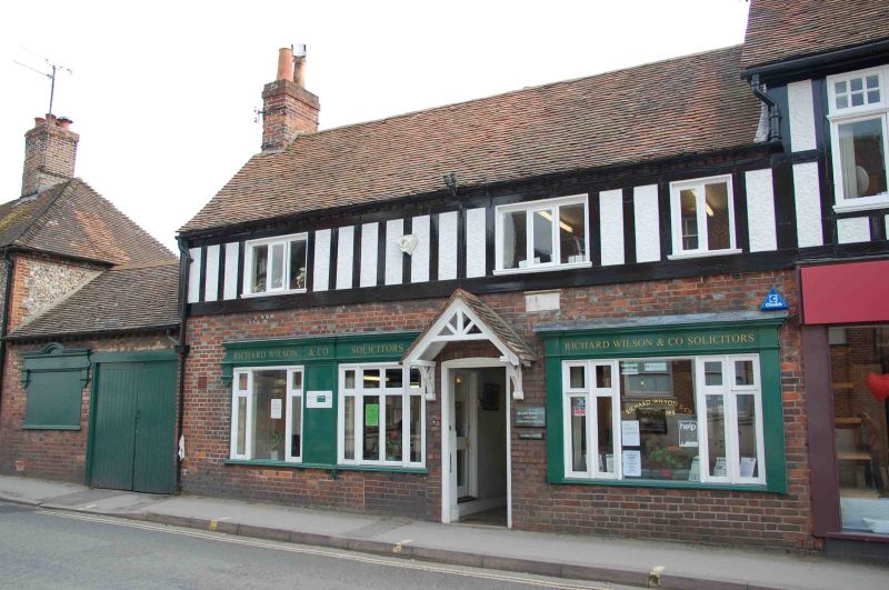
Cottage, now offices. Early C18 with C19 additions and C20 alterations. Red
brick; flint panels with red-brick dressings to left; old plain-tile roof; brick
ridge stacks. 2 storeys, 3-window range. C20 door to centre with segmental
arched head; C20 door to right with segmental arched head. Irregular
fenestration of C20 windows to original openings. Half-hipped cross-gable to
left, cross-gable to right. Interior not inspected.
Listing NGR: SU6002980781
External links are from the relevant listing authority and, where applicable, Wikidata. Wikidata IDs may be related buildings as well as this specific building. If you want to add or update a link, you will need to do so by editing the Wikidata entry.


Other nearby listed buildings
