Latitude: 50.9255 / 50°55'31"N
Longitude: -3.0929 / 3°5'34"W
OS Eastings: 323285
OS Northings: 114573
OS Grid: ST232145
Mapcode National: GBR M1.PXZY
Mapcode Global: FRA 46DN.JW8
Plus Code: 9C2RWWG4+5V
Entry Name: Higher Fyfett Farmhouse
Listing Date: 18 December 1986
Grade: II
Source: Historic England
Source ID: 1060235
English Heritage Legacy ID: 271215
ID on this website: 101060235
Location: Fyfett, Somerset, TA20
County: Somerset
District: Somerset West and Taunton
Civil Parish: Otterford
Traditional County: Somerset
Lieutenancy Area (Ceremonial County): Somerset
Tagged with: Farmhouse
ST21SW OTTERFORD CP
FYFETT
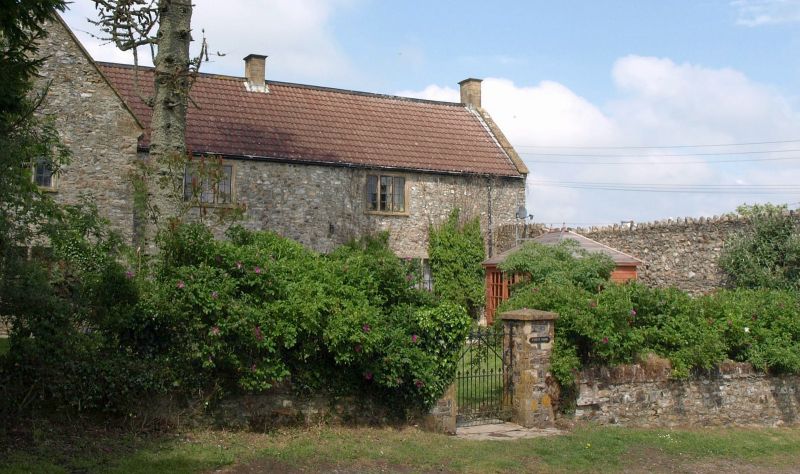
8/47 Higher Fyfett Farmhouse
II
Farmhouse. Dated 1677, restored 1861, reroofed and restored 1976-80. Chert stone random rubble formerly rendered, Ham
stone dressings, renewed mullions in reconstructed stone, concrete double Roman tiled roof, stone stacks to left of
through passage and centre of cross wing, evidence of former stack at right gable end with bread oven projection. Plan:
2-cell and cross passage with 2-cell cross wing left, former dairy at rear right. Two storeys, 1:2 bays, end bay left
gable fronted with square plaque in apex inscribed in incised lettering "Built 1677 Rest. 1861", all 3-light chamfered
stone mullions without hood moulds, entrance centre right with square headed doorway, late C20 door in period style.
Reconstructed stone mullions in returns, 2 single light windows inserted right gable end. Interior not seen. The
Masters and Day Map of Somerset published 1782 shows a house of some importance at Fyfett, but whether it is this
dwelling or one that formerly stood to the south is not clear. There are monuments in Otterford churchyard to the
Willie family of Fyfett.
Listing NGR: ST2477613149
External links are from the relevant listing authority and, where applicable, Wikidata. Wikidata IDs may be related buildings as well as this specific building. If you want to add or update a link, you will need to do so by editing the Wikidata entry.


Other nearby listed buildings