Approximate Location Map
Large Map »
Latitude: 51.2289 / 51°13'44"N
Longitude: 0.5468 / 0°32'48"E
OS Eastings: 577912
OS Northings: 150831
OS Grid: TQ779508
Mapcode National: GBR PRN.T72
Mapcode Global: VHJMM.FCDR
Plus Code: 9F326GHW+HP
Entry Name: Tilts House
Listing Date: 23 May 1967
Last Amended: 25 March 1987
Grade: II
Source: Historic England
Source ID: 1060761
English Heritage Legacy ID: 174491
ID on this website: 101060761
Location: Cock Street, Maidstone, Kent, ME17
County: Kent
District: Maidstone
Civil Parish: Boughton Monchelsea
Traditional County: Kent
Lieutenancy Area (Ceremonial County): Kent
Tagged with: House
BOUGHTON MONCHELSEA HEATH ROAD
TQ 75 SE (North side)
Cock Street
1/30 Tilts House
(formerly listed
23.5.67 as Tilts Farm House)
GV II
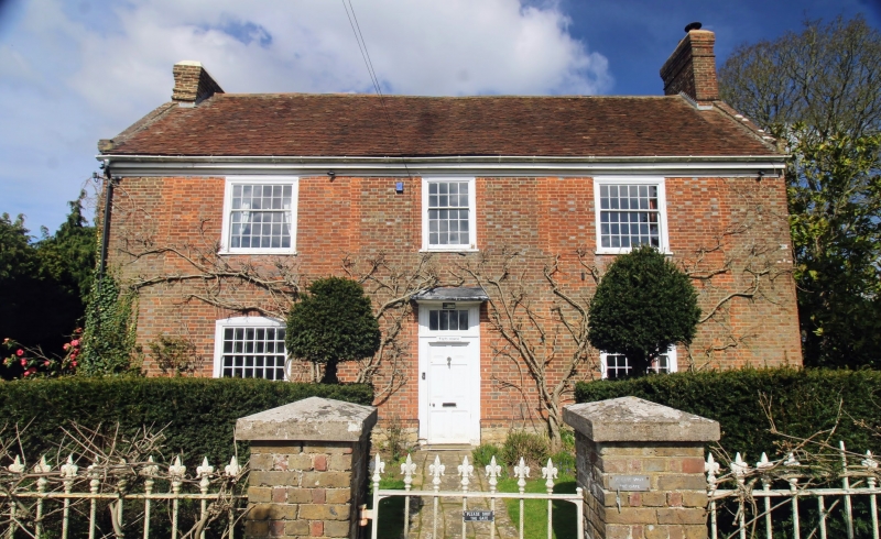
Farmhouse, now house. Early C18, with early-to-mid C19 alterations. Red
and grey brick in Flemish bond. Plain tile roof. Double depth, but ranges
possibly of slightly different dates. 2 storeys. Stone plinth, plain to
front range, galleted to rear. Moulded wooden eaves cornice. Brick-coped
and kneelered gable ends to each range. Gable end stacks to front range, and
gable end stack to left of rear range. Irregular fenestration of two
multipane sashes with shallow sloping 'hoods' and central 20-pane sash, all
in altered openings. Segmental heads to multipane ground-floor windows.
Central panelled door with 4-light rectangular fanlight and flat hood.
Interior: only partly inspected. High ceilings to front range with chamfered
axial beams. Panelled doors. Stone-flagged entrance hall, with C18 dog-leg
staircase rising towards rear of front range, branching twice to first floor
rooms of rear range. Iron range to rear stack dated 1720. See also items 1/31
and 1/32.
Listing NGR: TQ7791250831
External links are from the relevant listing authority and, where applicable, Wikidata. Wikidata IDs may be related buildings as well as this specific building. If you want to add or update a link, you will need to do so by editing the Wikidata entry.


Other nearby listed buildings
