Approximate Location Map
Large Map »
Latitude: 52.1916 / 52°11'29"N
Longitude: -2.2177 / 2°13'3"W
OS Eastings: 385217
OS Northings: 254841
OS Grid: SO852548
Mapcode National: GBR 1G4.J5D
Mapcode Global: VH92T.H5ZR
Plus Code: 9C4V5QRJ+JW
Entry Name: City Wall, Extending N from Junction of Nash's Passage with City Walls Road
Listing Date: 5 April 1971
Last Amended: 27 June 2001
Grade: II
Source: Historic England
Source ID: 1063804
English Heritage Legacy ID: 488637
ID on this website: 101063804
Location: Worcester, Worcestershire, WR1
County: Worcestershire
District: Worcester
Electoral Ward/Division: Cathedral
Parish: Non Civil Parish
Built-Up Area: Worcester
Traditional County: Worcestershire
Lieutenancy Area (Ceremonial County): Worcestershire
Church of England Parish: Worcester, St Martin's in the Cornmarket with St Swithun and St Paul
Church of England Diocese: Worcester
Tagged with: City walls
This list entry was subject to a Minor Amendment on 27/02/2012
SO8554NW
620-1/17/713
05/04/71
WORCESTER
CITY WALLS ROAD
(West side)
City Wall, extending N
from junction of Nash's
Passage with City Walls Road
(Formerly Listed as: City Walls)
(Formerly under City Wall, extending N
from junction of Noah's Passage
GV
II
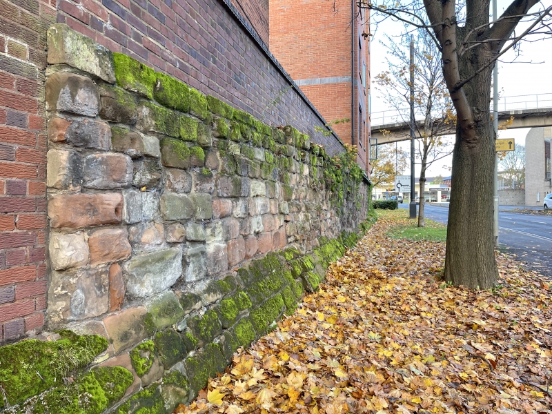
City wall. C14. Dressed red sandstone. Extends for approx. 54m
from E end of Nash's Passage to E end of Windsor Row.
Scheduled Ancient Monument.
External links are from the relevant listing authority and, where applicable, Wikidata. Wikidata IDs may be related buildings as well as this specific building. If you want to add or update a link, you will need to do so by editing the Wikidata entry.


Other nearby listed buildings
