Approximate Location Map
Large Map »
Latitude: 51.585 / 51°35'5"N
Longitude: -0.012 / 0°0'43"W
OS Eastings: 537828
OS Northings: 189217
OS Grid: TQ378892
Mapcode National: GBR KT.TXK
Mapcode Global: VHGQN.RF0B
Plus Code: 9C3XHXMQ+X5
Entry Name: St Mary's Churchyard Wise Family Tomb Close to South Wall of Tower
Listing Date: 24 February 1987
Last Amended: 15 September 1987
Grade: II
Source: Historic England
Source ID: 1065610
English Heritage Legacy ID: 206852
ID on this website: 101065610
Location: St Mary's Church, Central Parade, Waltham Forest, London, E17
County: London
District: Waltham Forest
Electoral Ward/Division: Hoe Street
Parish: Non Civil Parish
Built-Up Area: Waltham Forest
Traditional County: Essex
Lieutenancy Area (Ceremonial County): Greater London
Church of England Parish: Walthamstow St Mary the Virgin
Church of England Diocese: Chelmsford
Tagged with: Building
4/30
CHURCH END
Walthamstow, E17
(North side)
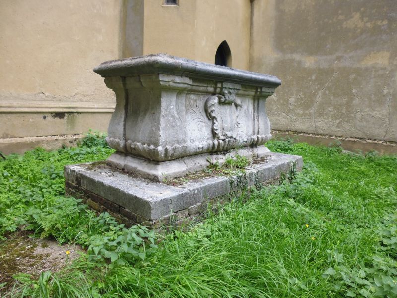
St Mary's Churchyard Tomb of Thomas Wise, close to south wall of tower
The address shall be
amended to read:-
CHURCH END
Walthamstow, E17
(North side)
St Mary's Churchyard Wise Family Tomb close to south wall of tower
------------------------------------
TQ 3789
4/30
CHURCH END
Walthamstow E17
(north side)
St Mary's Churchyard, Tomb of Thomas Wise, close to south wall of tower
II
Table tomb to Mr Thomas Wise, d.1710. Portland stone with greystone lid. Balusters
to corners, gadrooning to base. Cartouches and carved foliage to long sides.
Listing NGR: TQ3782889217
External links are from the relevant listing authority and, where applicable, Wikidata. Wikidata IDs may be related buildings as well as this specific building. If you want to add or update a link, you will need to do so by editing the Wikidata entry.


Other nearby listed buildings
