Approximate Location Map
Large Map »
Latitude: 51.3651 / 51°21'54"N
Longitude: -0.1634 / 0°9'48"W
OS Eastings: 527954
OS Northings: 164495
OS Grid: TQ279644
Mapcode National: GBR DD.ZCM
Mapcode Global: VHGRK.3YZD
Plus Code: 9C3X9R8P+2J
Entry Name: North churchyard wall including former fire-engine house at west end
Listing Date: 1 March 1974
Grade: II
Source: Historic England
Source ID: 1065684
English Heritage Legacy ID: 206728
ID on this website: 101065684
Location: Carshalton, Sutton, London, SM5
County: London
District: Sutton
Electoral Ward/Division: Carshalton Central
Parish: Non Civil Parish
Built-Up Area: Sutton
Traditional County: Surrey
Lieutenancy Area (Ceremonial County): Greater London
Church of England Parish: Carshalton All Saints
Church of England Diocese: Southwark
Tagged with: Building
This list entry was subject to a Minor Amendment on 22/01/2020
TQ 2764 SE
20/78
CARSHALTON
HIGH STREET (south side)
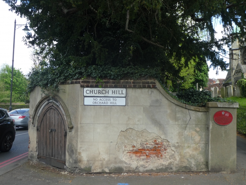
North churchyard wall including former fire-engine house at west end
GV
II
Wall of red brick with battered coping. Later C17 to C18 probably. At west end, wall returns south in two facets, stuccoed. In north-west facing facet, a two-centred doorway with dripmould to former C19 fire-engine house. Small ledged double doors with cover strips. At south end of west facing facet, a stuccoed pier.
The Greyhound Inn, wall to east of the Greyhound, Church of All Saints, North Churchyard wall and Nos 6 to 12 (Coach and Horses) form a group with Anne Boleyn's Well, St Mary's and Madeley Cottage in Church Hill and with the following items: with No 1 High Street and entrance gates to The Grove, with road bridge, Leoni bridge, culvert and retaining walls to Carshalton Ponds and with Honeywood Museum and walls, Honeywood Walk and The Gate House. From the south the Church forms a group with No 4 High Street, with churchyard walls and with wall to south of No 6 High Street.
Listing NGR: TQ2795464495
External links are from the relevant listing authority and, where applicable, Wikidata. Wikidata IDs may be related buildings as well as this specific building. If you want to add or update a link, you will need to do so by editing the Wikidata entry.


Other nearby listed buildings
