Latitude: 51.3654 / 51°21'55"N
Longitude: -0.1637 / 0°9'49"W
OS Eastings: 527930
OS Northings: 164529
OS Grid: TQ279645
Mapcode National: GBR DD.RF2
Mapcode Global: VHGRK.3YS4
Plus Code: 9C3X9R8P+5G
Entry Name: Road Bridge. Retaining walls of embankments of the pond to the west of North Street and its railings
Listing Date: 16 March 1954
Grade: II
Source: Historic England
Source ID: 1300556
English Heritage Legacy ID: 206721
ID on this website: 101300556
Location: Carshalton, Sutton, London, SM5
County: London
District: Sutton
Electoral Ward/Division: Carshalton Central
Parish: Non Civil Parish
Built-Up Area: Sutton
Traditional County: Surrey
Lieutenancy Area (Ceremonial County): Greater London
Church of England Parish: Carshalton All Saints
Church of England Diocese: Southwark
Tagged with: Road bridge
This list entry was subject to a Minor Amendment on 22/01/2020
TQ 2764 NE
18/67
CARSHALTON
HIGH STREET (north side)
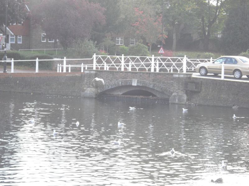
Road Bridge. Retaining walls of embankments of the pond to the west of North Street and its railings.
16.3.54
GV
II
1825-28. The first road bridge and embankment to be built across the Carshalton Ponds [formerly only a wooden footbridge]. Bridge of stock brick with one segmental arch with plain abutment piers and Portland stone dressings and keystone. Ironwork of intersecting iron railings. To either side of road embankment retaining walls of brick surmounted by horizontal cast iron rail which passes at intervals through cast iron standards with battered sides and ball finials. From the west side of the embankment this wall returns west along the south side of the Ponds as far as the "splash" before the Greyhound Public House.
Road bridge, Leoni Bridge, culvert and retaining walls to Carshalton Ponds form a group with No 1 High Street and entrance gates to the Grove, with Honeywood Museum and Wall and Gatehouse, Honeywood Walk, with Anne Boleyn's Well, St Mary's and Madeley Cottage in Church Hill and with the following items on the south side of the High Street: Greyhound Inn, wall to east of Greyhound Inn,Church of All Saints, north churchyard wall and Nos 6 and 12 High Street.
Listing NGR: TQ2793064529
External links are from the relevant listing authority and, where applicable, Wikidata. Wikidata IDs may be related buildings as well as this specific building. If you want to add or update a link, you will need to do so by editing the Wikidata entry.


Other nearby listed buildings