Latitude: 53.5028 / 53°30'10"N
Longitude: -2.3457 / 2°20'44"W
OS Eastings: 377168
OS Northings: 400734
OS Grid: SD771007
Mapcode National: GBR DW1Y.Z2
Mapcode Global: WH988.Y750
Plus Code: 9C5VGM33+4P
Entry Name: Wainwright's Farmhouse
Listing Date: 2 March 1973
Grade: II
Source: Historic England
Source ID: 1067512
English Heritage Legacy ID: 211964
ID on this website: 101067512
Location: Dales Brow, Salford, Greater Manchester, M27
County: Salford
Electoral Ward/Division: Swinton South
Parish: Non Civil Parish
Built-Up Area: Swinton
Traditional County: Lancashire
Lieutenancy Area (Ceremonial County): Greater Manchester
Church of England Parish: Swinton and Pendlebury Team
Church of England Diocese: Manchester
Tagged with: Farmhouse
SWINTON & PENDLEBURY FOLLY LANE SD 70 SE (east side) 2/9 Wainwright's 2/3/73 Farmhouse - II
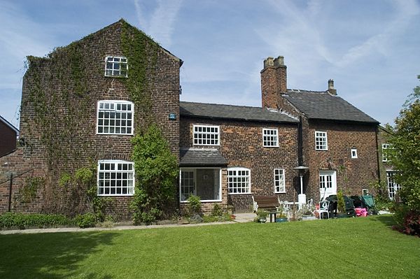
Farmhouse, now house. Various late C18 and early C19 dates with C20 alterations. English garden wall bond brick with slate roof. Irregular plan with a total of 6 bays on 2 and 3 storeys. Bay 1 is of 3 storeys whereas the rest is of 2 with varying rooflines. Bay 2 is set back behind a C20 porch. Door in bay 4. Small added wing to right and lean-to against left. Windows are all C20 replacement casements with cambered or flat brick-arched heads. Ridge and gable chimney stacks. Elliptical headed windows to rear one of which is blocked. Interior: hewn chamfered beams.
Listing NGR: SD7716800734
External links are from the relevant listing authority and, where applicable, Wikidata. Wikidata IDs may be related buildings as well as this specific building. If you want to add or update a link, you will need to do so by editing the Wikidata entry.


Other nearby listed buildings