Approximate Location Map
Large Map »
Latitude: 52.8058 / 52°48'20"N
Longitude: -1.2872 / 1°17'13"W
OS Eastings: 448151
OS Northings: 323373
OS Grid: SK481233
Mapcode National: GBR 7HZ.5DK
Mapcode Global: WHDHH.6QBW
Plus Code: 9C4WRP47+84
Entry Name: Manor Farmhouse and Outbuildings Surrounding Yard Immediately to Rear
Listing Date: 16 January 1989
Grade: II
Source: Historic England
Source ID: 1067745
English Heritage Legacy ID: 358237
ID on this website: 101067745
Location: Long Whatton, North West Leicestershire, LE12
County: Leicestershire
District: North West Leicestershire
Civil Parish: Long Whatton and Diseworth
Built-Up Area: Long Whatton
Traditional County: Leicestershire
Lieutenancy Area (Ceremonial County): Leicestershire
Church of England Parish: Long Whatton All Saints
Church of England Diocese: Leicester
Tagged with: Farmhouse
LONG WHATTON MAIN STREET
SK 42 SE
5/190 No 77 (Manor Farmhouse
and outbuildings
surrounding yard
immediately to rear)
- II
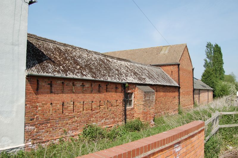
House with attached stables, cow-houses and barn. Late C18, house partly
remodelled mid C19, some C20 alterations. Brick, front to street and left side
of house roughcast and colourwashed. Front range has Swithland slate roof; left
side has C20 interlocking tiles; outbuildings have corrugated asbestos and tiled
roofs. Brick chimneys. Courtyard plan. L-plan house in front left corner is
of 2 storeys with 3 bays to front. Dentil eaves. Mid C19 boxed 4-pane sashes,
square to first floor, those to ground floor with segmental heads. Central
4-panelled door with radiating wooden glazing bars to semicircular fanlight, in
plain arched reveals with moulded wooden doorcase, keyblock and flat hood on
shaped brackets. To right are 3 blind stable bays with arched panels below and
square panels above. C20 3-light casement to upper storey in right gable.
Irregular altered openings to rear. Left side of house has irregular windows,
including 2 2-light horizontal sashes to upper storey, and door in C20 gabled
porch. 2 blind arched panels. Beyond rear wing of house is a dairy bay,
formerly a coach-house with large blind semicircular archway. At far end of
left wing are more stable bays, part used as garage, with lean-to extensions to
outer wall. Yard side of stable bays has windows and blind panels to left,
arched opening to stairs at left, arched central stable door, with flanking
pitching eyes in blind arched panels, and C20 garage doors to right. Along east
side of yard are cow-houses, part altered, with vent slits in rear wall. At
right-angles to north end of this range is a small 3-bay barn with blocked vent
slits, partly blocked central cart entry, and blind arched panel in left bay.
Other outbuildings attached to north of this are not of special architectural
interest. House retains late C18 features in rear wing but front wing was
remodelled internally mid C19. Dairy retains thrawts and cheese-press. Planned
farm complex with some architectural detailing.
Listing NGR: SK4815123373
External links are from the relevant listing authority and, where applicable, Wikidata. Wikidata IDs may be related buildings as well as this specific building. If you want to add or update a link, you will need to do so by editing the Wikidata entry.


Other nearby listed buildings
