Latitude: 51.7519 / 51°45'6"N
Longitude: -1.2674 / 1°16'2"W
OS Eastings: 450667
OS Northings: 206167
OS Grid: SP506061
Mapcode National: GBR 7XS.4CM
Mapcode Global: VHCXT.Z7BB
Plus Code: 9C3WQP2M+Q2
Entry Name: The Lodge
Listing Date: 28 June 1972
Grade: II
Source: Historic England
Source ID: 1067794
English Heritage Legacy ID: 245884
ID on this website: 101067794
Location: New Osney, Oxford, Oxfordshire, OX1
County: Oxfordshire
District: Oxford
Electoral Ward/Division: Carfax
Parish: Non Civil Parish
Built-Up Area: Oxford
Traditional County: Oxfordshire
Lieutenancy Area (Ceremonial County): Oxfordshire
Church of England Parish: Oxford St Barnabas with St Thomas the Martyr
Church of England Diocese: Oxford
Tagged with: Gatehouse
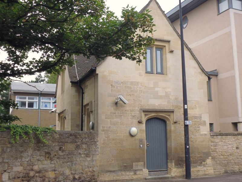
ST THOMAS' STREET
1.
1485
(North Side)
The Lodge
SP 5006 SE 7/842
II
2.
Early Cl9. Rubble. 2 storeys, 3 windows, 1:1:1 the centre bay set forward
with gable over. 1, 2 and 3 light mullioned windows with drip-moulds over.
Doorway in East gable end. Modern tile roof. (Probably built in 1839 as
the Parish School).
Listing NGR: SP5066706167
External links are from the relevant listing authority and, where applicable, Wikidata. Wikidata IDs may be related buildings as well as this specific building. If you want to add or update a link, you will need to do so by editing the Wikidata entry.


Other nearby listed buildings