Approximate Location Map
Large Map »
Latitude: 51.0716 / 51°4'17"N
Longitude: 1.0862 / 1°5'10"E
OS Eastings: 616302
OS Northings: 134781
OS Grid: TR163347
Mapcode National: GBR V0L.RF0
Mapcode Global: FRA F659.0Z4
Plus Code: 9F3333CP+JF
Entry Name: 124, High Street
Listing Date: 21 December 1973
Grade: II
Source: Historic England
Source ID: 1068944
English Heritage Legacy ID: 175127
ID on this website: 101068944
Location: Hythe, Folkestone and Hythe, Kent, CT21
County: Kent
District: Folkestone and Hythe
Civil Parish: Hythe
Built-Up Area: Hythe
Traditional County: Kent
Lieutenancy Area (Ceremonial County): Kent
Tagged with: Building
1.
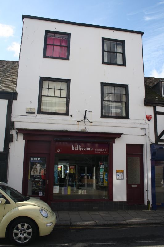
1253 HIGH STREET
(South Side)
No 124
TR 1634 NW 2/110
II GV
2.
C18. 3 storeys colour-washed. Hipped tiled roof. The side elevation is tile-hung.
2 sashes set in moulded architraves. Later shop front.
Nos 94 to 98 (even), No 102 and Nos 106 to 130 (even) form a group.
Listing NGR: TR1630234781
External links are from the relevant listing authority and, where applicable, Wikidata. Wikidata IDs may be related buildings as well as this specific building. If you want to add or update a link, you will need to do so by editing the Wikidata entry.


Other nearby listed buildings
