Approximate Location Map
Large Map »
Latitude: 51.0716 / 51°4'17"N
Longitude: 1.0863 / 1°5'10"E
OS Eastings: 616313
OS Northings: 134785
OS Grid: TR163347
Mapcode National: GBR V0L.RH5
Mapcode Global: FRA F659.11L
Plus Code: 9F3333CP+JG
Entry Name: 130, High Street
Listing Date: 21 December 1973
Grade: II
Source: Historic England
Source ID: 1068945
English Heritage Legacy ID: 175129
ID on this website: 101068945
Location: Hythe, Folkestone and Hythe, Kent, CT21
County: Kent
District: Folkestone and Hythe
Civil Parish: Hythe
Built-Up Area: Hythe
Traditional County: Kent
Lieutenancy Area (Ceremonial County): Kent
Tagged with: Building
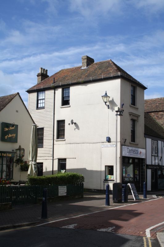
1.
1253 HIGH STREET
(South Side)
No 130
TR 1634 NW 2/112
II GV
2.
Early C19. 3 storeys stuccoed. Hipped tiled roof. 1 sash with glazing bars
intact, set in moulded architraves with console brackets to 1st floor windows
only. Modern shop front.
Nos 94 to 98 (even), No 102 and Nos 106 to 130 (even) form a group.
Listing NGR: TR1631434783
External links are from the relevant listing authority and, where applicable, Wikidata. Wikidata IDs may be related buildings as well as this specific building. If you want to add or update a link, you will need to do so by editing the Wikidata entry.


Other nearby listed buildings
